Home
Weather Dublin
WeatherRadar
RainfallRadar
TemperatureRadar
WindRadar
LightningRadar
Weather News
Editor's Pick
Discover the app
Weather widget
Contact us
Apps
    Home / Editor's Pick /

    Impacting UK & Ireland: Storms Elin and Fergus named

14:54
9 December 2023

Impacting UK & Ireland
Storms Elin and Fergus named

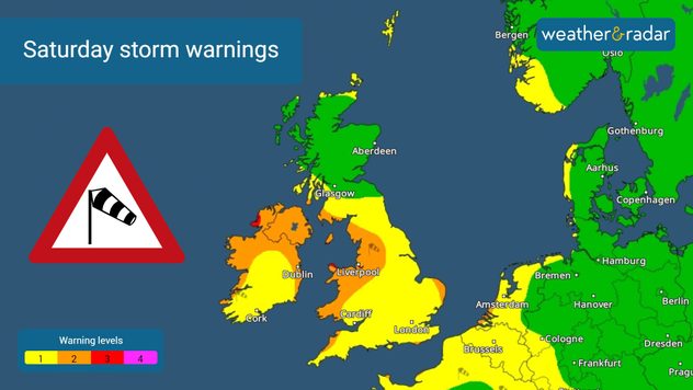
Storms Elin and Fergus have both been named, with Ireland feeling the brunt of both systems as gale force winds and heavy rain hit.

Both systems were named by Met Éireann earlier on Saturday, with the two storms making impact on the day. Elin reached western Ireland in the afternoon with wind gusts reaching 60 mph in Belmullet, these speeds were also met in Dublin.

Storm Elin

As Elin crosses the Irish Sea, wind speeds are expected to approach highs of 70 mph in Liverpool tonight. Heavy rainfall accompanies the winds, with up to 80 mm of precipitation expected in north-west England, south-west Scotland, and eastern Scotland.

Storm warning map
Storm warning map
Storm warning map
Storm warning map
1/4
Storm warnings in effect for Saturday.

More than 260 flood warnings are in effect as of Saturday afternoon, with 236 of these covering England.

Earlier this week, flooding already caused disruption in England, with schools forced to close in Somerset.

This week: Flooding across the UKread more

Storm Fergus

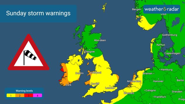
Fergus is a separate system hot on the tail of Elin in the Atlantic, which is expected to reach western Ireland on Sunday.

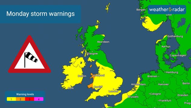
Ireland will again see the most forceful impacts from Fergus, with gale force winds returning for a second day.

These winds are likely to create high waves on Sunday, adding to the risk of coastal flooding along the western coast as it arrives.

Active storm season

Fergus marks the sixth named storm in three months of the 2023/24 storm season. It took 11 months for the first named storm of the 22/23 season.

Watch both systems as they progress on the WindRadar and WeatherRadar. If you are impacted by the storms, and it is safe to do so, be sure to capture the scene and show off how the weather looks near you on our uploader.

Activate weather alerts

Ryan Hathaway
More on the topic
Blood Moon rises early Friday morning. Partial lunar eclipse. . . Thursday 27 August 2026
Stages of a lunar eclipse
Thursday 27 August 2026

Partial lunar eclipse

Blood Moon rises early Friday morning
Rain and blustery winds spread. Frontal influence. . . Wednesday 2 September 2026
Split weather graphic showing widespread rain across the UK and Ireland alongside winds of 25-35 mph, strongest around Cardiff and the south of the UK.
Wednesday 2 September 2026

Frontal influence

Rain and blustery winds spread
Violent thunderstorms mark summer's end. Hail and gusts of wind. . Weather Videos. Thursday 27 August 2026
Severe thunderstorm warning map showing a level 3 red zone from eastern France toward Belgium, surrounded by orange and yellow alerts extending into western Germany.
Weather VideosThursday 27 August 2026

Hail and gusts of wind

Violent thunderstorms mark summer's end
All weather news
This might also interest you
Flooding, gales, and heavy snow. Storm Chandra. . . Tuesday 27 January 2026
Split image showing aerial flooding in a town with muddy water covering roads on the left, and a rural road on the right blocked by heavy snowfall with vans stopped and a person walking in snow.
Tuesday 27 January 2026

Storm Chandra

Flooding, gales, and heavy snow
Historic Storm Éowyn arrives. On this day.... . . Saturday 24 January 2026
Split image showing a person in a yellow jacket struggling against strong winds and heavy rain on a street at night on the left, and an Irish wind forecast map on the right with red and purple shading, gusts up to 75 mph, and a wind warning icon, divided by a curved white line.
Saturday 24 January 2026

On this day...

Historic Storm Éowyn arrives
Super Typhoon Bavi threatens Taiwan. Up to 1,000 mm of rain. . Weather Videos. Wednesday 8 July 2026
The image shows an intense tropical cyclone over the western Pacific, east of Taiwan and the Philippines. The centre of the system is depicted as a light purple and white vortex with a clearly visible eye, surrounded by a ring of red and orange areas indicating the strongest wind speeds. A white arrow marks the typhoon’s predicted track towards the north-west, in the direction of Taiwan. To the west of the storm lie the Philippines, with the cities of Manila and Cebu; to the north of these lies Taiwan, with Taipei. Further west, the Chinese coast, including Hong Kong, and parts of Vietnam can be seen. The coloured wind map shows predominantly green areas outside the storm’s core, indicating significantly weaker winds. White streamlines illustrate the typhoon’s anti-clockwise circulation in the Northern Hemisphere. The highest wind speeds are concentrated around the eye of the cyclone.
Weather VideosWednesday 8 July 2026

Up to 1,000 mm of rain

Super Typhoon Bavi threatens Taiwan
All articles
Weather & Radar

Weather & Radar is also available on

Google Play StoreApp Store

Company

Contact us Privacy Policy Legal info Accessibility statement

Services

Uploader

Socials

facebooktwitteryouTubelinkList