Home
Weather Dublin
WeatherRadar
RainfallRadar
TemperatureRadar
WindRadar
LightningRadar
Weather News
Editor's Pick
Discover the app
Weather widget
Contact us
Apps
    Home / Editor's Pick /

    Hurricane-force gusts and flash floods – Hurricane Lowell threatens Hawaii

09:48
8 September 2026

Gales and flash floods
Hurricane Lowell threatens Hawaii

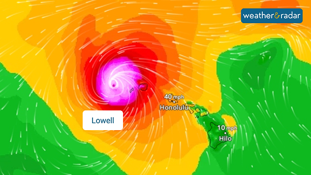
Hurricane Lowell is set to hit Hawaii. The western parts of the Pacific archipelago is bracing for hurricane-force winds of up to 124 mph.

The tropical storm is bringing with it heavy rainfall of up to 300 mm and dangerous waves.

WindRadar showing Hurricane Lowell north-west of Hawaii and its well-defined storm centre.
Hurricane Lowell on the WindRadar, just off the coast of the Hawaiian Islands

As a result, flash floods, landslides and power cuts are possible. As a precautionary measure, the authorities on Kauai have closed schools, government offices, parks, and campsites. Along the coast, residents in at-risk areas have been urged to prepare for evacuation.

It was only in August that Tropical Storm Lala struck the Hawaiian Islands and caused damage.

Keep an eye on developmentsLowell on WindRadar
Weather & Radar editorial team
More on the topic
Warm waters raise severe weather risk. Mediterranean bathtub. . Weather Videos. Friday 4 September 2026
Left: Map showing water temperatures in the Mediterranean; Right: Dark clouds over a stretch of Mediterranean coastline. A bolt of lightning strikes and a curtain of rain can be seen.
Weather VideosFriday 4 September 2026

Mediterranean bathtub

Warm waters raise severe weather risk
Europe's storm situation still volatile. Supercell danger. . . Friday 28 August 2026
Split screen. On the left, a weather map of Europe showing thunderstorms, lightning and a warning symbol. On the right, a photograph of a severe thunderstorm
Friday 28 August 2026

Supercell danger

Europe's storm situation still volatile
Rain and blustery winds spread. Frontal influence. . . Wednesday 2 September 2026
Split weather graphic showing widespread rain across the UK and Ireland alongside winds of 25-35 mph, strongest around Cardiff and the south of the UK.
Wednesday 2 September 2026

Frontal influence

Rain and blustery winds spread
All weather news
This might also interest you
New records for England and Wales. Broken again tomorrow?. . . Thursday 25 June 2026
Temperature map of southwest Britain on 25.06 showing extreme heat across southern Wales and southwest England, with Bute Park in Cardiff highlighted at 34.2°C and Yeovilton at 36.4°C amid widespread deep red heat zones.
Thursday 25 June 2026

Broken again tomorrow?

New records for England and Wales
Flooding, gales, and heavy snow. Storm Chandra. . . Tuesday 27 January 2026
Split image showing aerial flooding in a town with muddy water covering roads on the left, and a rural road on the right blocked by heavy snowfall with vans stopped and a person walking in snow.
Tuesday 27 January 2026

Storm Chandra

Flooding, gales, and heavy snow
Storm Chandra makes impact. Severe gales & heavy rain. . . Tuesday 27 January 2026
Split image showing strong winds over the UK on a forecast map and widespread rain and snow on a weather radar map.
Tuesday 27 January 2026

Severe gales & heavy rain

Storm Chandra makes impact
All articles
Weather & Radar

Weather & Radar is also available on

Google Play StoreApp Store

Company

Contact us Privacy Policy Legal info Accessibility statement

Services

Uploader

Socials

facebooktwitteryouTubelinkList