Home
Weather Dublin
WeatherRadar
RainfallRadar
TemperatureRadar
WindRadar
LightningRadar
Weather News
Editor's Pick
Discover the app
Weather widget
Contact us
Apps
    Home / Editor's Pick /

    Highest alert level - Massive typhoon in the Western Pacific

08:00
13 April 2026

Highest alert level
Massive typhoon in the Western Pacific

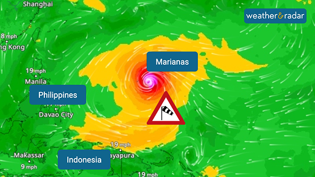
An extremely powerful typhoon has formed between Indonesia and the Philippines.

Typhoon Sinlaku is heading towards the Mariana Islands in the coming hours – with wind gusts of over 185 miles per hour, accompanied by heavy rainfall and dangerous storm surges.

WindRadar: Typhoon Sinlaku is heading towards the Mariana Islands.

The highest alert level has already been declared for the archipelago, which is part of the United States. The islands of Saipan, Tinian and Rota are particularly affected, as is Guam, the most densely populated island.

Did you know?

Super typhoons are among the strongest tropical cyclones in the world and are equivalent to a Category 5 hurricane. Guam was last hit by a severe typhoon in May 2023.

On the remote islands, flights have been cancelled and schools closed. The public are urged to avoid the coast and to leave their homes only in an emergency.

Clemens Teutsch-Zumtobel
More on the topic
Severe weather risk in holiday spots. Hail and heavy rain. . . Wednesday 19 August 2026
Split weather graphic showing intense thunderstorms and widespread lightning across northern Italy and Switzerland on the left, with severe warning zones from yellow to red around Milan and the southern Alps on the right.
Wednesday 19 August 2026

Hail and heavy rain

Severe weather risk in holiday spots
Turbulent conditions in southern Europe. Severe thunderstorms. . . Monday 24 August 2026
Weather map shows a risk of severe weather in parts of France and Italy, amongst other places
Monday 24 August 2026

Severe thunderstorms

Turbulent conditions in southern Europe
Late-summer views as shooting stars fly. Your weather - Your shots. . . Sunday 23 August 2026
Split image showing a meteor streaking through a star-filled night sky on the left and wispy white cirrus clouds sweeping across a vivid blue daytime sky on the right.
Sunday 23 August 2026

Your weather - Your shots

Late-summer views as shooting stars fly
All weather news
This might also interest you
Historic Storm Éowyn arrives. On this day.... . . Saturday 24 January 2026
Split image showing a person in a yellow jacket struggling against strong winds and heavy rain on a street at night on the left, and an Irish wind forecast map on the right with red and purple shading, gusts up to 75 mph, and a wind warning icon, divided by a curved white line.
Saturday 24 January 2026

On this day...

Historic Storm Éowyn arrives
Bright and warm conditions take hold. Spring-like outlook. . . Thursday 23 April 2026
Split UK map showing warm temperatures up to 21 degrees in orange on the left and clear sunny conditions with temperatures from 12 to 18 degrees on the right, with sun icons across the country.
Thursday 23 April 2026

Spring-like outlook

Bright and warm conditions take hold
Long-term trends need a pinch of salt. 40 °C in July?. . . Tuesday 30 June 2026
Temperature radar of 2022 heatwave where the all-time temperature record in the UK was set. Warning symbol overlain.
Tuesday 30 June 2026

40 °C in July?

Long-term trends need a pinch of salt
All articles
Weather & Radar

Weather & Radar is also available on

Google Play StoreApp Store

Company

Contact us Privacy Policy Legal info Accessibility statement

Services

Uploader

Socials

facebooktwitteryouTubelinkList