Home
Weather Dublin
WeatherRadar
RainfallRadar
TemperatureRadar
WindRadar
LightningRadar
Weather News
Editor's Pick
Discover the app
Weather widget
Contact us
Apps
    Home / Editor's Pick /

    Heavy showers prompt flash flood risk

08:51
26 August 2026

Thunder and hail
Heavy showers prompt flash flood risk

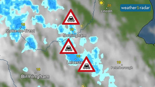
Weather radar map showing heavy shower around Nottingham and Leicester, with flood warning symbols highlightning areas at risk across the East Midlands.
Flood alerts are active across parts of the Midlands.

A number of flood alerts are already live Wednesday morning as heavy showers bring a renewed risk of flash flooding in parts of England and Wales.

Up to 50 mm of rain could fall through day, with heavy showers moving northwards in the morning. More widely accumulations of 20-30 mm are expected. Where the heaviest rain falls, surface flooding may arise.

Currently, five flood alerts cover parts of the Midlands from northern Nottinghamshire's River Maun down to tributaries in Leicester.

Further alerts are expected on Thursday, with another day of heavy rain and potential thunderstorms.

Staying on top of the flood risk

Flood alerts, warnings, and severe warnings are a live service and prone to change during the day. Keep an eye on official sources for the latest in your area.

Again, accumulations of 20 to 30 mm in a few hours are expected across the English Midlands into Wales, but with potentially higher total amounts of up to 75 mm for a few east facing areas at higher altitude.

Alongside the rainfall, the current set-up is also ripe for the outbreak of thunderstorms on both days and large hailstones are possible on Thursday too.

Ryan Hathaway
More on the topic
Much of Europe in storm mode. Twin low-pressure systems. . . Friday 9 October 2026
WindRadar for Europe, showing wind speeds of up to 40 mph and wind socks over particularly windy regions.
Friday 9 October 2026

Twin low-pressure systems

Much of Europe in storm mode
Hurricane threatens the US coast. First storm of the season. . . Thursday 8 October 2026
The WindRadar shows a powerful hurricane off the US Gulf Coast. Wind speeds of 75 miles per hour are being recorded around the centre of the storm.
Thursday 8 October 2026

First storm of the season

Hurricane threatens the US coast
Severe weather in Spain and Greece. Streets under water. . Weather Videos. Monday 5 October 2026
Severe weather near Barcelona, alongside a weather radar map showing heavy rain and thunderstorms.
Weather VideosMonday 5 October 2026

Streets under water

Severe weather in Spain and Greece
All weather news
This might also interest you
A stormy week in the skies above. Your weather - Your shots. . . Sunday 30 August 2026
Split image showing lightning branching beneath dark storm clouds above rooftops on the left and an orange-pink sunset over a calm sea on the right.
Sunday 30 August 2026

Your weather - Your shots

A stormy week in the skies above
Flooding, gales, and heavy snow. Storm Chandra. . . Tuesday 27 January 2026
Split image showing aerial flooding in a town with muddy water covering roads on the left, and a rural road on the right blocked by heavy snowfall with vans stopped and a person walking in snow.
Tuesday 27 January 2026

Storm Chandra

Flooding, gales, and heavy snow
Storm Chandra makes impact. Severe gales & heavy rain. . . Tuesday 27 January 2026
Split image showing strong winds over the UK on a forecast map and widespread rain and snow on a weather radar map.
Tuesday 27 January 2026

Severe gales & heavy rain

Storm Chandra makes impact
All articles
Weather & Radar

Weather & Radar is also available on

Google Play StoreApp Store

Company

Contact us Privacy Policy Legal info Accessibility statement

Services

Uploader

Socials

facebooktwitteryouTubelinkList