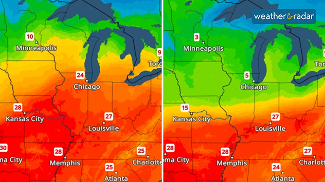
Home
Weather Dublin
WeatherRadar
RainfallRadar
TemperatureRadar
WindRadar
LightningRadar
Weather News
Editor's Pick
Discover the app
Weather widget
Contact us
Apps
    Home / Editor's Pick /

    From 25, to 5 degrees - USA: Temperatures are up and down

10:00
31 March 2026

From 25, to 5 degrees
USA: Temperatures are up and down

A sharp drop in temperature is on the way in parts of the US. Today, Chicago is still hovering around 25 degrees, but tomorrow temperatures will suddenly plummet to around 5 degrees.

A sharp drop in temperatures is on the way in the US. Maximum temperatures for today (left) and tomorrow (right).

After that, the temperature will shoot back up again, just like on a rollercoaster. By Thursday, the thermometer will be showing around 20 degrees again.

Chicago

Fr
13
25
Sa
18
28
Su
19
30
Mo
23
29
Tu
23
28
We
12
17
Th
10
17
Fr
9
17
Sa
12
20
Su
15
24
Mo
18
25
Tu
17
24
We
15
22
Th
15
23
Max (°C)
Min (°C)
moreless

New York

Fr
11
20
Sa
13
26
Su
19
31
Mo
18
24
Tu
17
32
We
23
33
Th
16
16
Fr
12
20
Sa
13
21
Su
16
24
Mo
17
25
Tu
18
27
We
20
27
Th
15
22
Max (°C)
Min (°C)
moreless

Boston

Fr
11
13
Sa
9
25
Su
17
29
Mo
11
24
Tu
16
31
We
19
32
Th
16
16
Fr
11
18
Sa
11
19
Su
12
21
Mo
13
21
Tu
14
25
We
16
23
Th
13
20
Max (°C)
Min (°C)
moreless

Philadelphia

Fr
12
20
Sa
10
27
Su
19
31
Mo
18
31
Tu
21
34
We
23
34
Th
18
24
Fr
12
20
Sa
13
23
Su
15
29
Mo
18
31
Tu
20
33
We
21
29
Th
16
24
Max (°C)
Min (°C)
moreless

Of course, this sudden drop in temperature won’t come without consequences. Things are set to get pretty rough, particularly in Iowa and northern Illinois: expect severe thunderstorms with heavy rain, hail and gusts of wind, and even the odd supercell.

On Thursday, the cold snap will reach the east coast: temperatures in New York will drop to 8 degrees, whilst in Boston they’ll be as low as a mere 4 degrees.

Glossary: What is a supercell?read more
Sebastian Keßler
More on the topic
Split image showing a calm coastal inlet and mountain landscape on the left, and a dramatic layered lenticular cloud above hills and trees on the right.
Sunday 10 May 2026

Your weather - Your shots

Scenic spring views across the countries
Satellite weather map of the UK and western Europe showing rain bands across Britain, a rain cloud icon over Scotland, and a thunderstorm icon near Belgium and northern France on Wednesday 13.05.
Wednesday 13 May 2026

Hail also possible

Thunderstorm risk for parts of the UK
On the left, a map of Europe shows temperature anomalies in April, with positive values in Western Europe and negative values in Eastern Europe. On the right, an industrial area can be seen, with chimneys and trees in the foreground.
Friday 8 May 2026

Record in Spain

Third warmest April on record
All weather news
This might also interest you
Split image showing coastal sunset with layered lenticular clouds over rooftops and palm trees on the left, and a green valley with river and hills under soft daylight on the right.
Sunday 19 April 2026

Your weather - Your shots

Seasonal warmth between spring thunder
plit image showing a double rainbow over a rocky shoreline on the left and sheep grazing in a green field under stormy clouds on the right.
Sunday 2 November 2025

Your weather - Your shots

Mixed conditions on an unsettled week
Split image showing strong winds over the UK on a forecast map and widespread rain and snow on a weather radar map.
Tuesday 27 January 2026

Severe gales & heavy rain

Storm Chandra makes impact
All articles
Weather & Radar

Weather & Radar is also available on

Google Play StoreApp Store

Company

Contact us Privacy Policy Legal info Accessibility statement

Services

Uploader

Socials

facebooktwitteryouTubelinkList