Home
Weather Dublin
WeatherRadar
RainfallRadar
TemperatureRadar
WindRadar
LightningRadar
Weather News
Editor's Pick
Discover the app
Weather widget
Contact us
Apps
    Home /

    Fresh front brings more rain in parts as it pushes east

10:06
10 September 2026

Pushing east
Fresh front brings more rain in parts

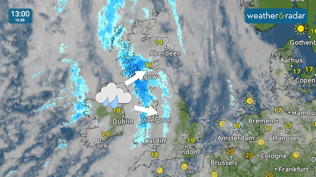
Weather map at 13:00 on 10.09 showing rain across Ireland, Scotland and northwest England, with arrows indicating showers moving east toward Liverpool.
Rain moves through Ireland and the UK on Thursday.

It's another wet, showery day for Ireland and parts of the UK as a fresh front pushes in from the Atlantic.

After moving through Ireland in the morning, bringing light showers as it does so, the front continues east into the afternoon bringing heavier rainfall.

After noon, this reaches the western coast of the UK, across Scotland, northern England, and Wales.

Later in the day, brisk winds begin to pick up behind the front. Gusts of 25 to 30 mph are expected widely, growing stronger for a spell in eastern Scotland.

Keep an eye on how the front affects the day on the WeatherRadar.

Ryan Hathaway
More on the topic
Hurricane Lowell threatens Hawaii. Gales and flash floods. . . Tuesday 8 September 2026
WindRadar showing Hurricane Lowell north-west of Hawaii and its well-defined storm centre.
Tuesday 8 September 2026

Gales and flash floods

Hurricane Lowell threatens Hawaii
Severe weather in southern Europe. Thunderstorms & heavy rain. . Weather Videos. Wednesday 9 September 2026
On the left, dark storm clouds over a coastline. On the right, a weather map shows thunderstorms over the western Mediterranean, with warning symbols for tornadoes, storms and hail.
Weather VideosWednesday 9 September 2026

Thunderstorms & heavy rain

Severe weather in southern Europe
A generally gusty Thursday. Moderate but notable wind. . . Wednesday 2 September 2026
Wind forecast showing widespread 25-30 mph winds across the UK and Ireland, including Glasgow, Dublin, Cork, Cardiff, and London, with a windsock symbol.
Wednesday 2 September 2026

Moderate but notable wind

A generally gusty Thursday
All weather news
This might also interest you
Europe's storm situation still volatile. Supercell danger. . . Friday 28 August 2026
Split screen. On the left, a weather map of Europe showing thunderstorms, lightning and a warning symbol. On the right, a photograph of a severe thunderstorm
Friday 28 August 2026

Supercell danger

Europe's storm situation still volatile
Slow moving rain brings flooding. More alerts live. . . Thursday 27 August 2026
Weather radar at 11:00 on 27.08 showing widespread heavy rain from Liverpool through the Midlands to eastern England, with an arrow indicating rain moving north.
Thursday 27 August 2026

More alerts live

Slow moving rain brings flooding
Extreme heat in Italy. Up to 45 degrees. . . Wednesday 26 August 2026
Split screen. On the left, a temperature map of Italy. On the right, a view of Taormina and Mount Etna
Wednesday 26 August 2026

Up to 45 degrees

Extreme heat in Italy
All articles
Weather & Radar

Weather & Radar is also available on

Google Play StoreApp Store

Company

Contact us Privacy Policy Legal info Accessibility statement

Services

Uploader

Socials

facebooktwitteryouTubelinkList