Home
Weather Dublin
WeatherRadar
RainfallRadar
TemperatureRadar
WindRadar
LightningRadar
Weather News
Editor's Pick
Discover the app
Weather widget
Contact us
Apps
    Home / Editor's Pick /

    Former hurricane to record-breaking storm - Isaias affecting Europe

11:00
14 October 2026

Isaias affecting Europe
Former hurricane to record storm

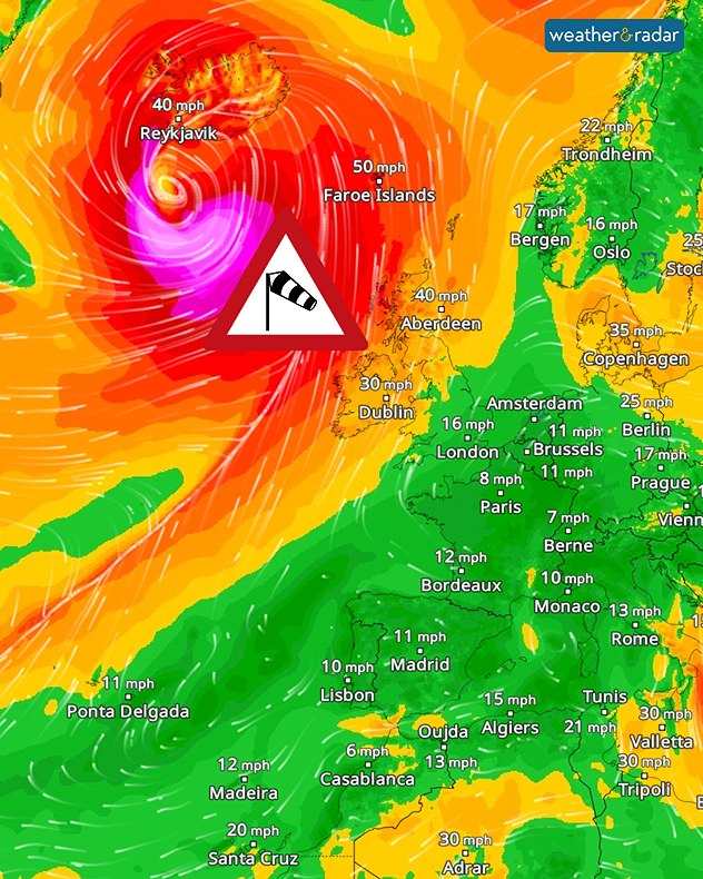
A massive storm system has developed over the North Atlantic. It has formed from the remnants of Hurricane Isaias, which made landfall on the US coast at the weekend.

Over the sea and along the southern coast of Iceland, the storm is reaching wind speeds of around 125 miles per hour.

Did you know?

Within just 24 hours, the air pressure associated with the low-pressure system has fallen by more than 50 hectopascals. We meteorologists call this ‘explosive cyclogenesis’. This is when a low-pressure system intensifies explosively within a short space of time.

The full force of the hurricane will not make landfall. However, Ireland and Scotland will feel the effects of the storm’s outer bands. At the same time, the low-pressure system is affecting wind patterns across large parts of central and south-western Europe.

Our global WindRadar shows the powerful storm system south of Iceland.

With the wind shifting to the south-west, warm air is flowing into Central Europe. As a result, temperatures are rising to around 20°C. In Spain and the south of France, it will get even warmer, with highs of around 30°C.

See the warmest temperatures todayTemperatureRadar
Weather & Radar editorial team
More on the topic
Gales build again for Ireland. Turbulent week ahead. . . Monday 12 October 2026
Wind map showing 40 mph winds near Galway, 30 mph near Cork, 25 mph near Dublin and 23 mph near Belfast, with a windsock symbol.
Monday 12 October 2026

Turbulent week ahead

Gales build again for Ireland
Severe storms expected in the Med. Risk of flooding. . . Tuesday 13 October 2026
The weather radar and warning map show severe thunderstorms and heavy rain in Greece and western Turkey.
Tuesday 13 October 2026

Risk of flooding

Severe storms expected in the Med
Warnings for a windswept Wednesday. Coastal gales. . . Tuesday 13 October 2026
Wind map showing 45 mph near Aberdeen, 40 mph near Glasgow and Cork, and red strong wind warning symbols across western Scotland and Ireland.
Tuesday 13 October 2026

Coastal gales

Warnings for a windswept Wednesday
All weather news
This might also interest you
New records for England and Wales. Broken again tomorrow?. . . Thursday 25 June 2026
Temperature map of southwest Britain on 25.06 showing extreme heat across southern Wales and southwest England, with Bute Park in Cardiff highlighted at 34.2°C and Yeovilton at 36.4°C amid widespread deep red heat zones.
Thursday 25 June 2026

Broken again tomorrow?

New records for England and Wales
A stormy week in the skies above. Your weather - Your shots. . . Sunday 30 August 2026
Split image showing lightning branching beneath dark storm clouds above rooftops on the left and an orange-pink sunset over a calm sea on the right.
Sunday 30 August 2026

Your weather - Your shots

A stormy week in the skies above
Super Typhoon Bavi threatens Taiwan. Up to 1,000 mm of rain. . Weather Videos. Wednesday 8 July 2026
The image shows an intense tropical cyclone over the western Pacific, east of Taiwan and the Philippines. The centre of the system is depicted as a light purple and white vortex with a clearly visible eye, surrounded by a ring of red and orange areas indicating the strongest wind speeds. A white arrow marks the typhoon’s predicted track towards the north-west, in the direction of Taiwan. To the west of the storm lie the Philippines, with the cities of Manila and Cebu; to the north of these lies Taiwan, with Taipei. Further west, the Chinese coast, including Hong Kong, and parts of Vietnam can be seen. The coloured wind map shows predominantly green areas outside the storm’s core, indicating significantly weaker winds. White streamlines illustrate the typhoon’s anti-clockwise circulation in the Northern Hemisphere. The highest wind speeds are concentrated around the eye of the cyclone.
Weather VideosWednesday 8 July 2026

Up to 1,000 mm of rain

Super Typhoon Bavi threatens Taiwan
All articles
Weather & Radar

Weather & Radar is also available on

Google Play StoreApp Store

Company

Contact us Privacy Policy Legal info Accessibility statement

Services

Uploader

Socials

facebooktwitteryouTubelinkList