Home
Weather Dublin
WeatherRadar
RainfallRadar
TemperatureRadar
WindRadar
LightningRadar
Weather News
Editor's Pick
Discover the app
Weather widget
Contact us
Apps
    Home / Editor's Pick /

    Ex-hurricane GABRIELLE reaches western Mediterranean – risk of flooding due to severe thunderstorms

09:00
29 September 2025

Severe thunderstorms
Ex-hurricane in the western Mediterranean

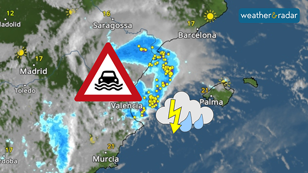
Severe thunderstorms with heavy rain on Spain's Mediterranean coast: Valencia particularly at risk of flooding.

Ex-Hurricane GABRIELLE has reached the western Mediterranean and will bring heavy rainfall, particularly along the east coast of Spain and the Balearic Islands, until Tuesday evening.

Flood risk

The province of Valencia in particular is experiencing torrential rainfall of 200 to 300 litres per square metre, with peaks even higher. Fortunately, most of the rain is falling over the open sea. By way of comparison, the city of Valencia receives an average of around 480 litres over the course of a whole year.

The popular holiday islands of Ibiza and Mallorca will also experience turbulent weather. Severe thunderstorms could also bring heavy rainfall here.

This is how showers and thunderstorms move inDevelopment in the weather radar

On Sunday evening, severe weather struck the area around Zaragoza in north-eastern Spain. Flash floods swept away cars and caused devastating damage.

Late in the evening, the first rainfall reached the coastal city of Valencia:

Kathrin Bogensperger
More on the topic
Stormy weather in parts of Europe. Low-pressure system. . . Friday 21 August 2026
Weather radar showing a low-pressure system over the Alps and its track towards the Baltic States. Next to it, a flooded road.
Friday 21 August 2026

Low-pressure system

Stormy weather in parts of Europe
Chance of thundery showers breaking out. Over the coming days. . . Tuesday 18 August 2026
Split weather graphic showing a yellow thunderstorm warning across eastern England alongside radar with heavy showers and lightning near Sheffield, Leicester and East Anglia.
Tuesday 18 August 2026

Over the coming days

Chance of thundery showers breaking out
Flood alerts after heavy showers. Risk in northern England. . . Thursday 20 August 2026
Weather radar map showing persistent heavy rain across northern England around Liverpool, Manchester and Newcastle, with a flood warning symbol highlighting the risk.
Thursday 20 August 2026

Risk in northern England

Flood alerts after heavy showers
All weather news
This might also interest you
Storm Chandra makes impact. Severe gales & heavy rain. . . Tuesday 27 January 2026
Split image showing strong winds over the UK on a forecast map and widespread rain and snow on a weather radar map.
Tuesday 27 January 2026

Severe gales & heavy rain

Storm Chandra makes impact
A frozen start to the weekend. Icy conditions. . . Friday 13 February 2026
UK temperature map dated 14.02 showing widespread subzero values in blue shading, with readings such as −4 in Glasgow, −3 in Dublin, and −2 in London, alongside a blue thermometer icon.
Friday 13 February 2026

Icy conditions

A frozen start to the weekend
Turbulent weather in the Canary Islands. Storm and rain. . . Friday 12 December 2025
Weather graphic showing rain and wind fields over the Canary Islands and a central warning symbol.
Friday 12 December 2025

Storm and rain

Turbulent weather in the Canary Islands
All articles
Weather & Radar

Weather & Radar is also available on

Google Play StoreApp Store

Company

Contact us Privacy Policy Legal info Accessibility statement

Services

Uploader

Socials

facebooktwitteryouTubelinkList