Home
Weather Dublin
WeatherRadar
RainfallRadar
TemperatureRadar
WindRadar
LightningRadar
Weather News
Editor's Pick
Discover the app
Weather widget
Contact us
Apps
    Home / Editor's Pick /

    Europe's summer set to to break records - Extreme heat and drought

08:37
11 August 2026

Extreme heat and drought
Europe's summer set to to break records

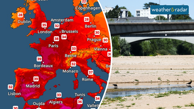
It’s set to be very hot again this week – major rivers such as the Loire in France are running almost dry. - © picture alliance / Xinhua News Agency | Wu Huiwo

This summer in Western Europe has been exceptionally warm so far: June and July combined were 2.79 degrees above the long-term average and are on course to set a new record.

Repeated heatwaves have affected France, Germany, the Benelux countries and parts of the UK in particular.

At the same time, large parts of Western Europe are experiencing extreme drought. Parched soil can barely release any moisture through evaporation and is therefore less able to cool the surrounding area – this further intensifies the heat and causes soil to dry out even more.

The effects are evident in rivers and seas: the Rhine, Loire, and Danube are carrying unusually low water levels in many places.

At the same time, water temperatures have risen sharply, off the coast of Mallorca, for example, the water temperature in the Mediterranean was measured at around 33°C, a new record.

1 day ago

A new heatwave, with temperatures reaching up to 40°C in Western Europe, is set to make the situation even worse this week with no sign of any significant relief from cooler air or rain.

Niklas Weise
More on the topic
Stormy day in parts of the UK & Ireland. Lightning potential. . . Tuesday 4 August 2026
Satellite and lightning map of Scotland showing widespread rain and thunderstorms across the Highlands and western Scotland, with lightning strikes around the west coast and Hebrides. A thunderstorm icon highlights the active weather, while temperatures range from 15°C in Aberdeen to 24°C in Newcastle.
Tuesday 4 August 2026

Lightning potential

Stormy day in parts of the UK & Ireland
Cooler nights on the horizon. For parts of Europe. . . Thursday 6 August 2026
Temperature Radar showing the night-time lows in Central Europe. Cooler air is reaching the west and north in particular, whilst the south-east remains significantly warmer.
Thursday 6 August 2026

For parts of Europe

Cooler nights on the horizon
Huge hailstones in Poland. Severe weather hits towns. . . Friday 7 August 2026
Friday 7 August 2026

Severe weather hits towns

Huge hailstones in Poland
All weather news
This might also interest you
Super Typhoon Bavi threatens Taiwan. Up to 1,000 mm of rain. . Weather Videos. Wednesday 8 July 2026
The image shows an intense tropical cyclone over the western Pacific, east of Taiwan and the Philippines. The centre of the system is depicted as a light purple and white vortex with a clearly visible eye, surrounded by a ring of red and orange areas indicating the strongest wind speeds. A white arrow marks the typhoon’s predicted track towards the north-west, in the direction of Taiwan. To the west of the storm lie the Philippines, with the cities of Manila and Cebu; to the north of these lies Taiwan, with Taipei. Further west, the Chinese coast, including Hong Kong, and parts of Vietnam can be seen. The coloured wind map shows predominantly green areas outside the storm’s core, indicating significantly weaker winds. White streamlines illustrate the typhoon’s anti-clockwise circulation in the Northern Hemisphere. The highest wind speeds are concentrated around the eye of the cyclone.
Weather VideosWednesday 8 July 2026

Up to 1,000 mm of rain

Super Typhoon Bavi threatens Taiwan
Flooding, gales, and heavy snow. Storm Chandra. . . Tuesday 27 January 2026
Split image showing aerial flooding in a town with muddy water covering roads on the left, and a rural road on the right blocked by heavy snowfall with vans stopped and a person walking in snow.
Tuesday 27 January 2026

Storm Chandra

Flooding, gales, and heavy snow
Historic Storm Éowyn arrives. On this day.... . . Saturday 24 January 2026
Split image showing a person in a yellow jacket struggling against strong winds and heavy rain on a street at night on the left, and an Irish wind forecast map on the right with red and purple shading, gusts up to 75 mph, and a wind warning icon, divided by a curved white line.
Saturday 24 January 2026

On this day...

Historic Storm Éowyn arrives
All articles
Weather & Radar

Weather & Radar is also available on

Google Play StoreApp Store

Company

Contact us Privacy Policy Legal info Accessibility statement

Services

Uploader

Socials

facebooktwitteryouTubelinkList