Home
Weather Dublin
WeatherRadar
RainfallRadar
TemperatureRadar
WindRadar
LightningRadar
Weather News
Editor's Pick
Discover the app
Weather widget
Contact us
Apps
    Home / Editor's Pick /

    Drought brings flash flood risks as rain returns

08:57
19 August 2026

As rain returns
Drought brings flash flood risks

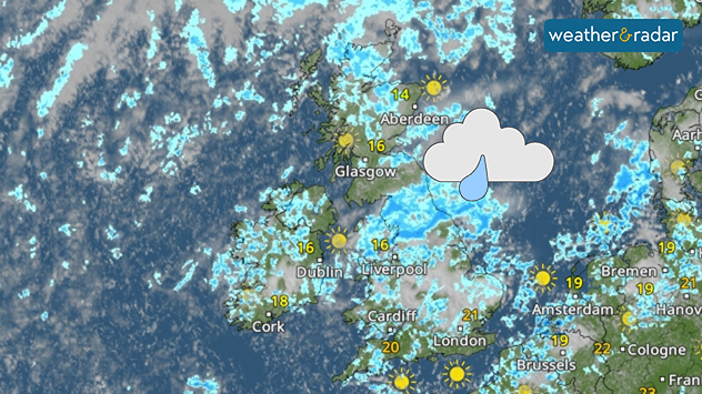
Weather radar map of the UK and Ireland showing widespread showers and rain, especially across England, with brighter spells in Scotland and southern England.
A much wetter look on the WeatherRadar come Thursday than we've become used to.

Many parts of England are set to see the first widespread rainfall in over a month this week, a return that could result in flooding while still in an official drought.

Showers are becoming more visible from Wednesday, with heavier and potentially thundery outbursts, on Thursday. These pass through many regions under a drought declaration and water use restrictions.

After months of unusually hot and dry conditions, the ground soil will not be able to efficiently absorb this rainfall. Instead, the baked and parched ground will allow the water to collect, possibly leading to flash floods in some areas.

A return of showers is also not going to meaningfully improve the drought situation any time soon.

Currently, 71% of England is in drought according to the Environment Agency, with taps running dry in parts of Kent while Wisley, Surrey has just seen the first rain in 62 days.

To sufficiently recover ground moisture and reservoir levels, which as of August 13th were resting at 65% of capacity, more sustained rainfall is needed.

In the meantime, the risk of flash floods will persist where coming showers turn heavy. Keep one eye on the WeatherRadar to see when they reach your area.

Ryan Hathaway
More on the topic
Switch from drought to waterlogged. Ireland's new challenge. . . Thursday 1 October 2026
Split image showing widespread heavy rain across Ireland besid aerial farmland covered by extensive standing floodwater.
Thursday 1 October 2026

Ireland's new challenge

Switch from drought to waterlogged
Stormy weather in the Mediterranean. Torrential rain and floods. . . Wednesday 30 September 2026
Split screen. On the left, a weather map of Spain and France showing rainfall, temperatures and weather symbols. On the right, a flooded road with a car.
Wednesday 30 September 2026

Torrential rain and floods

Stormy weather in the Mediterranean
Hurricane POLO remains dangerous. Many storms in the Pacific. . . Thursday 24 September 2026
Thursday 24 September 2026

Many storms in the Pacific

Hurricane POLO remains dangerous
All weather news
This might also interest you
Historic Storm Éowyn arrives. On this day.... . . Saturday 24 January 2026
Split image showing a person in a yellow jacket struggling against strong winds and heavy rain on a street at night on the left, and an Irish wind forecast map on the right with red and purple shading, gusts up to 75 mph, and a wind warning icon, divided by a curved white line.
Saturday 24 January 2026

On this day...

Historic Storm Éowyn arrives
Storm Chandra makes impact. Severe gales & heavy rain. . . Tuesday 27 January 2026
Split image showing strong winds over the UK on a forecast map and widespread rain and snow on a weather radar map.
Tuesday 27 January 2026

Severe gales & heavy rain

Storm Chandra makes impact
Super Typhoon Bavi threatens Taiwan. Up to 1,000 mm of rain. . Weather Videos. Wednesday 8 July 2026
The image shows an intense tropical cyclone over the western Pacific, east of Taiwan and the Philippines. The centre of the system is depicted as a light purple and white vortex with a clearly visible eye, surrounded by a ring of red and orange areas indicating the strongest wind speeds. A white arrow marks the typhoon’s predicted track towards the north-west, in the direction of Taiwan. To the west of the storm lie the Philippines, with the cities of Manila and Cebu; to the north of these lies Taiwan, with Taipei. Further west, the Chinese coast, including Hong Kong, and parts of Vietnam can be seen. The coloured wind map shows predominantly green areas outside the storm’s core, indicating significantly weaker winds. White streamlines illustrate the typhoon’s anti-clockwise circulation in the Northern Hemisphere. The highest wind speeds are concentrated around the eye of the cyclone.
Weather VideosWednesday 8 July 2026

Up to 1,000 mm of rain

Super Typhoon Bavi threatens Taiwan
All articles
Weather & Radar

Weather & Radar is also available on

Google Play StoreApp Store

Company

Contact us Privacy Policy Legal info Accessibility statement

Services

Uploader

Socials

facebooktwitteryouTubelinkList