Home
Weather Dublin
WeatherRadar
RainfallRadar
TemperatureRadar
WindRadar
LightningRadar
Weather News
Editor's Pick
Discover the app
Weather widget
Contact us
Apps
    Home / Editor's Pick /

    Did you spot them? Northern Lights shine over Europe

11:00
24 April 2023

Did you spot them?
Northern Lights shine over Europe

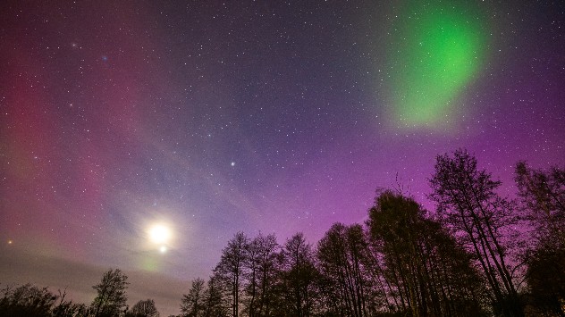
This time-lapse of the aurora was captured by user Chantal Anders in Ense, Germany.

The UK and Europe were treated to a widespread display of the Northern Lights on Sunday, one of the final shows of the season.

Late Sunday evening, a powerful aurora borealis reached far into Europe.

Visible as far as the Alps, the geomagnetic storm appeared a day after the Lyrid meteor shower reached its peak.

Northern Lights
Northern Lights seen in Brandenburg, Germany. - © Sarah Böhm

The Northern Lights actually happen all year round, but since the Sun's rays are a million times more powerful, we can only see the display when it's dark.

What causes auroras?read more

Therefore, it is typically during the winter months that we have a good chance of seeing the Northern Lights.

Aurora displays are starting to become more commonplace in the UK and Ireland as the Sun enters the most active phase of its solar cycle.

As the Sun approaches this phase, which it should reach in 2025, larger and more frequent solar flares and coronal mass ejection events will shoot solar particles towards Earth, triggering auroras.

If you were one of the lucky ones who saw the Northern Lights, we want to see your photos and videos too! Use the uploader to submit your shots.

Weather & Radar editorial team
More on the topic
Forest fires rage in southern Europe. Drought and wind. . . Monday 6 July 2026
Split screen. On the left, a weather map of France and Spain showing the plumes of smoke from the forest fires. On the right, a fire-fighting aircraft in action.
Monday 6 July 2026

Drought and wind

Forest fires rage in southern Europe
Lee waves flow over the UK and Ireland. On the WeatherRadar. . . Monday 6 July 2026
Satellite weather map of the UK and Ireland showing parallel bands of low cloud highlighted over southern Scotland and northern England, with additional cloud streets over Wales and western England circled in white.
Monday 6 July 2026

On the WeatherRadar

Lee waves flow over the UK and Ireland
Heat-health alerts ahead of heatwave. Across England. . . Tuesday 7 July 2026
Temperature map of the UK and western Europe showing hot conditions across Britain, with temperatures reaching 33°C near London, 29°C around Cardiff, 24°C near Liverpool, and a large heat warning symbol highlighting elevated heat risk.
Tuesday 7 July 2026

Across England

Heat-health alerts ahead of heatwave
All weather news
This might also interest you
Long-term trends need a pinch of salt. 40 °C in July?. . . Tuesday 30 June 2026
Temperature radar of 2022 heatwave where the all-time temperature record in the UK was set. Warning symbol overlain.
Tuesday 30 June 2026

40 °C in July?

Long-term trends need a pinch of salt
Seasonal warmth between spring thunder. Your weather - Your shots. . . Sunday 19 April 2026
Split image showing coastal sunset with layered lenticular clouds over rooftops and palm trees on the left, and a green valley with river and hills under soft daylight on the right.
Sunday 19 April 2026

Your weather - Your shots

Seasonal warmth between spring thunder
Super Typhoon Bavi threatens Taiwan. Up to 1,000 mm of rain. . Weather Videos. Wednesday 8 July 2026
The image shows an intense tropical cyclone over the western Pacific, east of Taiwan and the Philippines. The centre of the system is depicted as a light purple and white vortex with a clearly visible eye, surrounded by a ring of red and orange areas indicating the strongest wind speeds. A white arrow marks the typhoon’s predicted track towards the north-west, in the direction of Taiwan. To the west of the storm lie the Philippines, with the cities of Manila and Cebu; to the north of these lies Taiwan, with Taipei. Further west, the Chinese coast, including Hong Kong, and parts of Vietnam can be seen. The coloured wind map shows predominantly green areas outside the storm’s core, indicating significantly weaker winds. White streamlines illustrate the typhoon’s anti-clockwise circulation in the Northern Hemisphere. The highest wind speeds are concentrated around the eye of the cyclone.
Weather VideosWednesday 8 July 2026

Up to 1,000 mm of rain

Super Typhoon Bavi threatens Taiwan
All articles
Weather & Radar

Weather & Radar is also available on

Google Play StoreApp Store

Company

Contact us Privacy Policy Legal info Accessibility statement

Services

Uploader

Socials

facebooktwitteryouTubelinkList