Home
Weather Dublin
WeatherRadar
RainfallRadar
TemperatureRadar
WindRadar
LightningRadar
Weather News
Editor's Pick
Discover the app
Weather widget
Contact us
Apps
    Home / Editor's Pick /

    Devastating damage: Hurricane MELISSA wreaks havoc in the Caribbean in Jamaica, Cuba and Haiti

11:41
30 October 2025

Devastating damage
Hurricane Melissa rages in the Caribbean

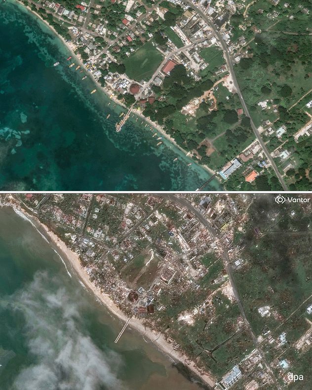
Satellite image shows destruction in Jamaica
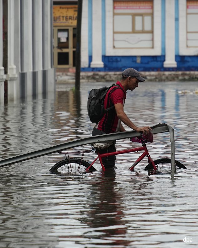
Damage in Cuba
Floods in Cuba
Hurricane damage in Haiti
1/5
Only the outer walls of this church in Jamaica remain standing. - © dpa

With torrential rain, destructive winds and metre-high waves, Hurricane Melissa caused massive damage and loss of life in the Caribbean. After Jamaica, Cuba, and Haiti were also severely affected.

In Jamaica, the hurricane devastated entire regions. Houses, roads, and bridges were destroyed. At least nine people lost their lives. Power was cut off in many places.

The situation was similar in Cuba. The east of the country was particularly badly impacted, with many coffee and banana plantations devastated. Flooding caused by extremely heavy rain also caused extensive damage in Haiti, where at least 24 people died.

On its way further north, the storm has now passed over the Bahamas archipelago. People had also been evacuated there beforehand. The hurricane is now heading towards the Bermuda Islands.

Position and trajectory of the hurricaneWindRadar
Dr. Bernd Maurer
Ryan Hathaway
with material from dpa
More on the topic
Summer in full flow. Your weather - Your shots. . . Sunday 5 July 2026
Split image showing golden crepuscular rays streaming through sunset clouds over the countryside on the left, and glowing blue noctilucent clouds above silhouetted trees and traffic lights at twilight on the right.
Sunday 5 July 2026

Your weather - Your shots

Summer in full flow
Cooler nights and lower dew points. Less oppressive heatwave. . . Thursday 9 July 2026
Split image showing the London skyline in hazy golden sunset light in the left and an overnight temperature map of the UK and Ireland on the right, with minimum temperatures ranging from 13°C in northeast Scotland to 18°C in southern England.
Thursday 9 July 2026

Less oppressive heatwave

Cooler nights and lower dew points
Lee waves flow over the UK and Ireland. On the WeatherRadar. . . Monday 6 July 2026
Satellite weather map of the UK and Ireland showing parallel bands of low cloud highlighted over southern Scotland and northern England, with additional cloud streets over Wales and western England circled in white.
Monday 6 July 2026

On the WeatherRadar

Lee waves flow over the UK and Ireland
All weather news
This might also interest you
A frozen start to the weekend. Icy conditions. . . Friday 13 February 2026
UK temperature map dated 14.02 showing widespread subzero values in blue shading, with readings such as −4 in Glasgow, −3 in Dublin, and −2 in London, alongside a blue thermometer icon.
Friday 13 February 2026

Icy conditions

A frozen start to the weekend
Storm Chandra makes impact. Severe gales & heavy rain. . . Tuesday 27 January 2026
Split image showing strong winds over the UK on a forecast map and widespread rain and snow on a weather radar map.
Tuesday 27 January 2026

Severe gales & heavy rain

Storm Chandra makes impact
Super Typhoon Bavi threatens Taiwan. Up to 1,000 mm of rain. . Weather Videos. Wednesday 8 July 2026
The image shows an intense tropical cyclone over the western Pacific, east of Taiwan and the Philippines. The centre of the system is depicted as a light purple and white vortex with a clearly visible eye, surrounded by a ring of red and orange areas indicating the strongest wind speeds. A white arrow marks the typhoon’s predicted track towards the north-west, in the direction of Taiwan. To the west of the storm lie the Philippines, with the cities of Manila and Cebu; to the north of these lies Taiwan, with Taipei. Further west, the Chinese coast, including Hong Kong, and parts of Vietnam can be seen. The coloured wind map shows predominantly green areas outside the storm’s core, indicating significantly weaker winds. White streamlines illustrate the typhoon’s anti-clockwise circulation in the Northern Hemisphere. The highest wind speeds are concentrated around the eye of the cyclone.
Weather VideosWednesday 8 July 2026

Up to 1,000 mm of rain

Super Typhoon Bavi threatens Taiwan
All articles
Weather & Radar

Weather & Radar is also available on

Google Play StoreApp Store

Company

Contact us Privacy Policy Legal info Accessibility statement

Services

Uploader

Socials

facebooktwitteryouTubelinkList