Home
Weather Dublin
WeatherRadar
RainfallRadar
TemperatureRadar
WindRadar
LightningRadar
Weather News
Editor's Pick
Discover the app
Weather widget
Contact us
Apps
    Home / Editor's Pick /

    Deluge starts the week - Flood warnings with heavy rain arriving

09:00
8 February 2026

Deluge starts the week
Flood warnings with heavy rain arriving

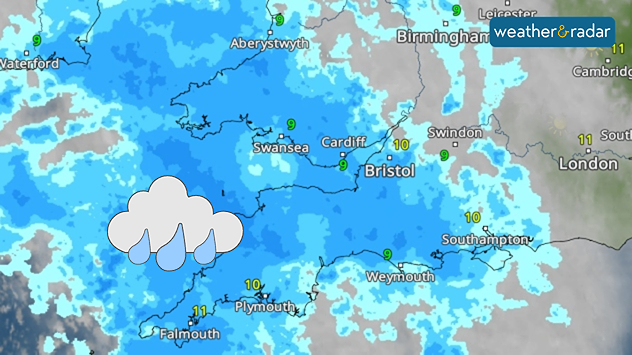
Monday sees heavy rain settle in.

Flood warnings are live across the UK, with a focus in the south-west where heavy rain will fall over saturated ground on Monday.

There are currently 88 flood warnings, indicating flooding is expected, primarily in the south-west and stretching into the English Midlands.

An additional 223 flood alerts, where flooding is possible, have also been issued by the Environment Agency.

Changing warnings

Flood warnings are a live service, the number active may have changed. Check warnings near you for the latest.

Up to 30 mm of rain is expected in areas exposed to southeasterly winds, with around 15 mm in other areas.

After Monday's deluge, further heavy rain is expected to arrive on Tuesday exacerbating issues with saturated ground unable to absorb the water.

Keep an eye on the WeatherRadar for the latest conditions around you.

Ryan Hathaway
More on the topic
Autumn colours light the skies. Your weather - Your shots. . . Sunday 13 September 2026
Split image showing a fiery red-orange sunset over a rural road and fields beside a golden sea sunset with a silhouetted seabird in flight.
Sunday 13 September 2026

Your weather - Your shots

Autumn colours light the skies
Hurricane threat off the coast of Mexico. Storm and rain. . . Monday 21 September 2026
Split image showing a powerful tropical system southwest of Acapulco on a wind map and palm trees bending sharply in strong winds.
Monday 21 September 2026

Storm and rain

Hurricane threat off the coast of Mexico
Huge low-pressure system off Iceland. Impacting the UK & Ireland. . . Wednesday 16 September 2026
WeatherRadar showing a large low-pressure system over the North Atlantic between Greenland and Iceland.
Wednesday 16 September 2026

Impacting the UK & Ireland

Huge low-pressure system off Iceland
All weather news
This might also interest you
Storm Chandra makes impact. Severe gales & heavy rain. . . Tuesday 27 January 2026
Split image showing strong winds over the UK on a forecast map and widespread rain and snow on a weather radar map.
Tuesday 27 January 2026

Severe gales & heavy rain

Storm Chandra makes impact
Long-term trends need a pinch of salt. 40 °C in July?. . . Tuesday 30 June 2026
Temperature radar of 2022 heatwave where the all-time temperature record in the UK was set. Warning symbol overlain.
Tuesday 30 June 2026

40 °C in July?

Long-term trends need a pinch of salt
Super Typhoon Bavi threatens Taiwan. Up to 1,000 mm of rain. . Weather Videos. Wednesday 8 July 2026
The image shows an intense tropical cyclone over the western Pacific, east of Taiwan and the Philippines. The centre of the system is depicted as a light purple and white vortex with a clearly visible eye, surrounded by a ring of red and orange areas indicating the strongest wind speeds. A white arrow marks the typhoon’s predicted track towards the north-west, in the direction of Taiwan. To the west of the storm lie the Philippines, with the cities of Manila and Cebu; to the north of these lies Taiwan, with Taipei. Further west, the Chinese coast, including Hong Kong, and parts of Vietnam can be seen. The coloured wind map shows predominantly green areas outside the storm’s core, indicating significantly weaker winds. White streamlines illustrate the typhoon’s anti-clockwise circulation in the Northern Hemisphere. The highest wind speeds are concentrated around the eye of the cyclone.
Weather VideosWednesday 8 July 2026

Up to 1,000 mm of rain

Super Typhoon Bavi threatens Taiwan
All articles
Weather & Radar

Weather & Radar is also available on

Google Play StoreApp Store

Company

Contact us Privacy Policy Legal info Accessibility statement

Services

Uploader

Socials

facebooktwitteryouTubelinkList