Home
Weather Dublin
WeatherRadar
RainfallRadar
TemperatureRadar
WindRadar
LightningRadar
Weather News
Editor's Pick
Discover the app
Weather widget
Contact us
Apps
    Home / Weather News /

    Breakfast brief: Plenty of showers, heavier to the south
04:00
25 July 2024

Breakfast brief
Plenty of showers, heavier to the south

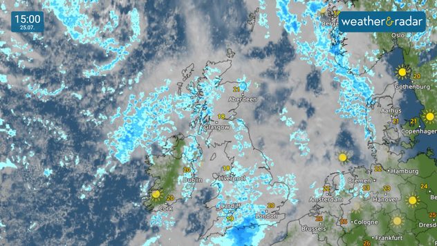
Showers on the WeatherRadar through the day - keep your umbrellas handy!

Plenty of showers around, with lots of cloud too as several weather fronts sweep west to east.

Kickstarting your morning

Welcome to your breakfast briefing, preparing you for the day's weather and offering a sneak peek at today's articles!

Weather outlook

A cloudy and rather overcast day across the board, with scattered showers developing across large swathes of the UK and Ireland.

Showers merging to a more persistent and organised spell of rain in the south-west, spreading eastwards across southern England through the late afternoon and evening. Some late spells of sunshine across Ireland.

Showers persisting in the east heading into the nighttime period, along with north-west Scotland, with clearer skies developing elsewhere.

What's coming up in the news

We are continuing to explore the world of storm chasing with the latest blog from our storm chasing team. This time, our US reporter Jonathan Petramala shares his story of reporting from the field, chasing down dangerous weather. Read more later today.

Did you miss these?

Your latest weather trendread also
Forest fires spread through Marbellaread also
Iceland volcanoes may erupt for decadesread also

Shot from the vault

We tend to dig into the archives each morning, but starting today we are also starting to look across the world. Our users are constantly sending incredible pictures from around the globe.

If you want to get involved, just tap the image icon to upload your own, or use one of our dedicated uploaders for the UK or Ireland.

We share the best shots every Sunday afternoon in the app, and throughout the week on our social channels!

Weather & Radar editorial team
More on the topic
Europe's summer set to to break records. Extreme heat and drought. . . Tuesday 11 August 2026
Split image showing a European heat map with temperatures reaching 39°C in France and Spain on the left, and a severely depleted river with exposed sandy banks beneath a bridge on the right.
Tuesday 11 August 2026

Extreme heat and drought

Europe's summer set to to break records
Hottest day of the year so far. Close to August record. . . Thursday 13 August 2026
Temperature map of London showing 38.1°C at Kew Gardens, with surrounding readings of 35–36°C and deep red shading indicating extreme heat.
Thursday 13 August 2026

Close to August record

Hottest day of the year so far
Late season views as summer rolls on. Your weather - Your shots. . . Sunday 9 August 2026
Split image showing a horseback ride along a green hillside trail beneath blue skies on the left and a small sailboat on a calm coastal bay under broken clouds on the right.
Sunday 9 August 2026

Your weather - Your shots

Late season views as summer rolls on
All weather news
This might also interest you
Storm Chandra makes impact. Severe gales & heavy rain. . . Tuesday 27 January 2026
Split image showing strong winds over the UK on a forecast map and widespread rain and snow on a weather radar map.
Tuesday 27 January 2026

Severe gales & heavy rain

Storm Chandra makes impact
Turbulent weather in the Canary Islands. Storm and rain. . . Friday 12 December 2025
Weather graphic showing rain and wind fields over the Canary Islands and a central warning symbol.
Friday 12 December 2025

Storm and rain

Turbulent weather in the Canary Islands
Super Typhoon Bavi threatens Taiwan. Up to 1,000 mm of rain. . Weather Videos. Wednesday 8 July 2026
The image shows an intense tropical cyclone over the western Pacific, east of Taiwan and the Philippines. The centre of the system is depicted as a light purple and white vortex with a clearly visible eye, surrounded by a ring of red and orange areas indicating the strongest wind speeds. A white arrow marks the typhoon’s predicted track towards the north-west, in the direction of Taiwan. To the west of the storm lie the Philippines, with the cities of Manila and Cebu; to the north of these lies Taiwan, with Taipei. Further west, the Chinese coast, including Hong Kong, and parts of Vietnam can be seen. The coloured wind map shows predominantly green areas outside the storm’s core, indicating significantly weaker winds. White streamlines illustrate the typhoon’s anti-clockwise circulation in the Northern Hemisphere. The highest wind speeds are concentrated around the eye of the cyclone.
Weather VideosWednesday 8 July 2026

Up to 1,000 mm of rain

Super Typhoon Bavi threatens Taiwan
All articles
Weather & Radar

Weather & Radar is also available on

Google Play StoreApp Store

Company

Contact us Privacy Policy Legal info Accessibility statement

Services

Uploader

Socials

facebooktwitteryouTubelinkList