Home
Weather Dublin
WeatherRadar
RainfallRadar
TemperatureRadar
WindRadar
LightningRadar
Weather News
Editor's Pick
Discover the app
Weather widget
Contact us
Apps
    Home / Editor's Pick /

    Over the coming days - Chance of thundery showers breaking out

14:17
18 August 2026

Over the coming days
Chance of thundery showers breaking out

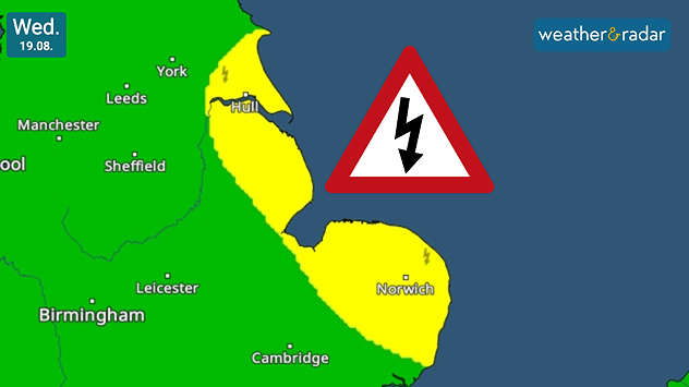
Weather warning map for Wednesday 19.08 showing yellow thunderstorm risk areas along eastern England from near Hull to Norwich, with a lightning warning symbol.
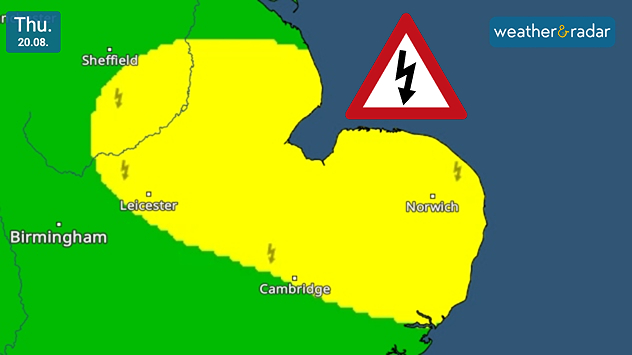
Weather warning map for Thursday 20.08 showing a broad yellow thunderstorm risk area across eastern England, including Leicester, Cambridge and Norwich, with a lightning warning symbol.
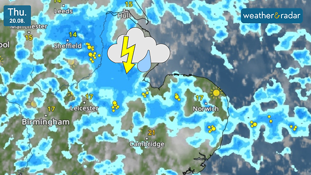
Weather radar map for Thursday 20.08 showing widespread showers and thunderstorms across eastern England, with lightning strikes around Sheffield, Leicester, Cambridge and Norwich.
1/3
Warnings in the app hug the east coast of England initially.

Parts of eastern England may see outbreaks of thundery showers from Wednesday with our own warnings covering the east coast before moving more inland.

On Wednesday, the risk of outbreaks rests predominantly across the east coast of England, in a stretch from Bridlington to Leiston, north-east of Ipswich which is not covered.

By Thursday, the risk extends into the East Midlands, as far as Derbyshire as continued showers hold the potential to bring short-lived thunder and lightning.

Ryan Hathaway
More on the topic
Record warmth in the Mediterranean. High water temperatures. . . Tuesday 18 August 2026
Split graphic showing a hot southern Europe temperature map beside a sunny Mediterranean beach, with a sea-temperature icon highlighting very warm coastal waters.
Tuesday 18 August 2026

High water temperatures

Record warmth in the Mediterranean
Getting through the latest heatwave. Tips to beat the heat. . . Tuesday 11 August 2026
Split graphic showing temperatures up to 35°C in England and 28°C in Ireland beside a person applying sunscreen, with a heat warning symbol highlighting hot weather.
Tuesday 11 August 2026

Tips to beat the heat

Getting through the latest heatwave
Your moments from the solar eclipse. A unique sight. . . Wednesday 12 August 2026
Split image showing a total solar eclipse glowing through dramatic clouds on the left and a multi-exposure eclipse sequence tracing the Sun across a blue sky on the right.
Wednesday 12 August 2026

A unique sight

Your moments from the solar eclipse
All weather news
This might also interest you
Long-term trends need a pinch of salt. 40 °C in July?. . . Tuesday 30 June 2026
Temperature radar of 2022 heatwave where the all-time temperature record in the UK was set. Warning symbol overlain.
Tuesday 30 June 2026

40 °C in July?

Long-term trends need a pinch of salt
Bright and warm conditions take hold. Spring-like outlook. . . Thursday 23 April 2026
Split UK map showing warm temperatures up to 21 degrees in orange on the left and clear sunny conditions with temperatures from 12 to 18 degrees on the right, with sun icons across the country.
Thursday 23 April 2026

Spring-like outlook

Bright and warm conditions take hold
Storm Chandra makes impact. Severe gales & heavy rain. . . Tuesday 27 January 2026
Split image showing strong winds over the UK on a forecast map and widespread rain and snow on a weather radar map.
Tuesday 27 January 2026

Severe gales & heavy rain

Storm Chandra makes impact
All articles
Weather & Radar

Weather & Radar is also available on

Google Play StoreApp Store

Company

Contact us Privacy Policy Legal info Accessibility statement

Services

Uploader

Socials

facebooktwitteryouTubelinkList