Home / Editor's Pick /

Winter takes a break – weather conditions undergo fundamental change

10:25
24 November 2025

Winter takes a break
Weather conditions change dramatically

Thursday's WeatherRadar clearly shows the Atlantic low pressure system bringing major weather changes to Europe.

After the brief winter interlude, signs now point to mild weather. The general weather situation is changing and putting winter on hold for the time being.

From the second half of the week onwards, low-pressure systems from the Atlantic will increasingly prevail. Not only will they bring changeable weather, but they will also draw warm air from North Africa. This means that a significant rise in temperature is on the way.

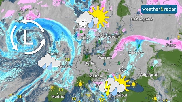
Snow fans now need a lot of patience

Maximum temperatures in Western Europe will rise to 10 to 15 degrees, and even higher in the warmest regions of Spain and Portugal. But it will also become milder in Scandinavia: instead of persistent frost, temperatures above zero will be common, with only the far north experiencing light frost.

Once established, these weather conditions are likely to persist. Atlantic lows will remain active, with highs from the east having little chance of developing.

For snow fans, this means patience is required – conditions are likely to remain mild and often wet well into December.

London

Mo
6
7
Tu
4
7
We
-1
8
Th
8
13
Fr
8
11
Sa
6
10
Su
3
7
Mo
7
14
Tu
13
14
We
11
15
Th
11
13
Fr
10
12
Sa
10
13
Su
8
11
Max (°C)
Min (°C)
moreless

Birmingham

Mo
2
7
Tu
1
6
We
-2
8
Th
8
13
Fr
7
10
Sa
5
7
Su
2
7
Mo
7
12
Tu
10
13
We
10
12
Th
7
11
Fr
8
12
Sa
9
12
Su
6
10
Max (°C)
Min (°C)
moreless

Dublin

Mo
7
10
Tu
3
8
We
3
12
Th
12
15
Fr
9
10
Sa
5
8
Su
4
9
Mo
9
13
Tu
9
11
We
6
9
Th
6
10
Fr
8
12
Sa
11
13
Su
8
11
Max (°C)
Min (°C)
moreless

Edinburgh

Mo
3
8
Tu
0
6
We
-1
8
Th
7
13
Fr
9
9
Sa
6
8
Su
1
8
Mo
8
12
Tu
9
11
We
7
10
Th
6
9
Fr
6
10
Sa
9
12
Su
7
9
Max (°C)
Min (°C)
moreless

Cardiff

Mo
5
9
Tu
3
9
We
-2
11
Th
11
14
Fr
9
11
Sa
7
9
Su
5
9
Mo
9
14
Tu
12
14
We
11
13
Th
9
12
Fr
10
13
Sa
9
12
Su
7
10
Max (°C)
Min (°C)
moreless

Belfast

Mo
6
10
Tu
3
8
We
2
10
Th
10
14
Fr
8
9
Sa
3
8
Su
2
8
Mo
8
13
Tu
8
11
We
6
8
Th
5
10
Fr
8
11
Sa
11
13
Su
9
11
Max (°C)
Min (°C)
moreless
Jürgen Vollmer
Ryan Hathaway
More on the topic
Weather radar for Europe showing numerous showers and weather map showing cold air at high altitude
Tuesday 18 November 2025

Influence of cold air

Patchwork quilt of showers over Europe
Temperature map of Europe showing wintry conditions in the north-east, and summer warmth in the south-east.
Friday 21 November 2025

Winter meets summer

Large temperature contrasts in Europe
Weather map of the UK and Ireland showing widespread blue shading and temperatures around -3°C to 0°C, with a thermometer icon on the left.
Wednesday 19 November 2025

Widely below 0 °C

Frozen end to the week
All weather news
This might also interest you
plit image showing a double rainbow over a rocky shoreline on the left and sheep grazing in a green field under stormy clouds on the right.
Sunday 2 November 2025

Your weather - Your shots

Mixed conditions on an unsettled week
Mammatus clouds
Thursday 21 August 2025

Unusual view

Mammatus clouds over Ireland
Weather map of the UK and Ireland showing scattered showers with cloudy patches across much of the region, especially around western and northern areas. Sunshine symbols appear over London, Cardiff, and parts of southern England, while temperatures range from 17°C to 18°C in most places. Areas of heavier rain are visible over the Atlantic to the west.
Friday 29 August 2025

Breakfast brief

Unsettled conditions into the weekend
All articles
Weather & Radar

Weather & Radar

Google Play StoreApp Store

Company

Contact us Privacy Policy Legal info Accessibility statement

Services

Uploader

Socials

facebooktwitteryouTubelinkList