Home
Weather Dublin
WeatherRadar
RainfallRadar
TemperatureRadar
WindRadar
LightningRadar
Weather News
Editor's Pick
Discover the app
Weather widget
Contact us
Apps
    Home / Weather News /

    -60C in Siberia: Lowest temperature of winter

14:00
12 December 2022

-60C in Siberia
Lowest temperature of winter

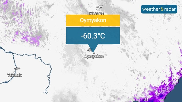
Oymyakon Siberia fell to -60.3C.

For the first time this year, the temperature has reached below -60C in the Northern Hemisphere.

Oymyakon in Siberia recorded temperatures of -60.3C on Sunday December 11th, though has recorded below -70C in the past.

Whilst Siberia is no stranger with sub-zero temperatures, holding some of the world's coldest records, these kinds of temperatures have been notably earlier than usual, currently 12C below average for the time of year there.

It is the first time this year that the mercury has plummeted below -60C in the Northern Hemisphere, with Sunday's reading falling close to a record for this time of year for the station.

Privacy Policy
Weather & Radar editorial team
More on the topic
Sunset views mark the start of the month. Your weather - Your shots. . . Sunday 4 October 2026
Split image showing offshore wind turbines beneath a pink-purple sky and a fiery red-orange sunset above silhouetted rooftops.
Sunday 4 October 2026

Your weather - Your shots

Sunset views mark the start of the month
Short burst of chilly mornings. A taste of winter. . . Wednesday 7 October 2026
Split temperature maps showing a cold 3-8°C start across the UK and Ireland followed by much milder 12-16°C conditions.
Wednesday 7 October 2026

A taste of winter

Short burst of chilly mornings
Hurricane threatens the US coast. First storm of the season. . . Thursday 8 October 2026
The WindRadar shows a powerful hurricane off the US Gulf Coast. Wind speeds of 75 miles per hour are being recorded around the centre of the storm.
Thursday 8 October 2026

First storm of the season

Hurricane threatens the US coast
All weather news
This might also interest you
Super Typhoon Bavi threatens Taiwan. Up to 1,000 mm of rain. . Weather Videos. Wednesday 8 July 2026
The image shows an intense tropical cyclone over the western Pacific, east of Taiwan and the Philippines. The centre of the system is depicted as a light purple and white vortex with a clearly visible eye, surrounded by a ring of red and orange areas indicating the strongest wind speeds. A white arrow marks the typhoon’s predicted track towards the north-west, in the direction of Taiwan. To the west of the storm lie the Philippines, with the cities of Manila and Cebu; to the north of these lies Taiwan, with Taipei. Further west, the Chinese coast, including Hong Kong, and parts of Vietnam can be seen. The coloured wind map shows predominantly green areas outside the storm’s core, indicating significantly weaker winds. White streamlines illustrate the typhoon’s anti-clockwise circulation in the Northern Hemisphere. The highest wind speeds are concentrated around the eye of the cyclone.
Weather VideosWednesday 8 July 2026

Up to 1,000 mm of rain

Super Typhoon Bavi threatens Taiwan
Historic Storm Éowyn arrives. On this day.... . . Saturday 24 January 2026
Split image showing a person in a yellow jacket struggling against strong winds and heavy rain on a street at night on the left, and an Irish wind forecast map on the right with red and purple shading, gusts up to 75 mph, and a wind warning icon, divided by a curved white line.
Saturday 24 January 2026

On this day...

Historic Storm Éowyn arrives
Long-term trends need a pinch of salt. 40 °C in July?. . . Tuesday 30 June 2026
Temperature radar of 2022 heatwave where the all-time temperature record in the UK was set. Warning symbol overlain.
Tuesday 30 June 2026

40 °C in July?

Long-term trends need a pinch of salt
All articles
Weather & Radar

Weather & Radar is also available on

Google Play StoreApp Store

Company

Contact us Privacy Policy Legal info Accessibility statement

Services

Uploader

Socials

facebooktwitteryouTubelinkList