Home / Editor's Pick /

Ex-hurricane GABRIELLE reaches western Mediterranean – risk of flooding due to severe thunderstorms

09:00
29 September 2025

Severe thunderstorms
Ex-hurricane in the western Mediterranean
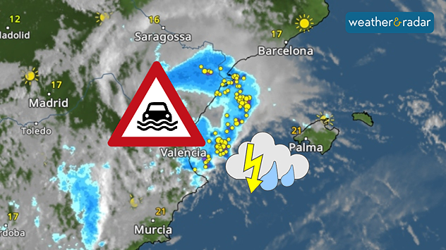
Severe thunderstorms with heavy rain on Spain's Mediterranean coast: Valencia particularly at risk of flooding.

Ex-Hurricane GABRIELLE has reached the western Mediterranean and will bring heavy rainfall, particularly along the east coast of Spain and the Balearic Islands, until Tuesday evening.

Flood risk

The province of Valencia in particular is experiencing torrential rainfall of 200 to 300 litres per square metre, with peaks even higher. Fortunately, most of the rain is falling over the open sea. By way of comparison, the city of Valencia receives an average of around 480 litres over the course of a whole year.

The popular holiday islands of Ibiza and Mallorca will also experience turbulent weather. Severe thunderstorms could also bring heavy rainfall here.

This is how showers and thunderstorms move inDevelopment in the weather radar

On Sunday evening, severe weather struck the area around Zaragoza in north-eastern Spain. Flash floods swept away cars and caused devastating damage.

Late in the evening, the first rainfall reached the coastal city of Valencia:

Kathrin Bogensperger
More on the topic
WindRadar shows wind speeds exceeding 150 kilometres per hour on the coast of China
Wednesday 24 September 2025

Damage and fatalities

Typhoon RAGASA rages in Southeast Asia
pinecones
Tuesday 23 September 2025

Did you know?

How pine cones aid the weather forecast
A split image shows two rainbow scenes: on the left, a rainbow arcs above offshore wind turbines against a dark grey sky; on the right, a double rainbow appears over the sea with waves breaking onto a sandy beach.
Sunday 21 September 2025

Your weather - Your shots

Colourful displays under stormy skies
All weather news
This might also interest you
Weather map showing a split in north-south conditions of the UK. Scotland sees widespread cloud cover while England and Wales have clear skies.
Friday 15 August 2025

Clouds on the move

North-south split in conditions
Split weather map showing the UK and Ireland. The left side illustrates strong winds circulating around a low-pressure system, with gusts of 20–30 mph highlighted in orange and yellow. The right side shows radar imagery with widespread blue rain bands and patches of thunderstorms, especially over northern England and Scotland.
Thursday 28 August 2025

Breakfast brief

Remaining widely unsettled
Weather map of the UK and Ireland showing scattered showers with cloudy patches across much of the region, especially around western and northern areas. Sunshine symbols appear over London, Cardiff, and parts of southern England, while temperatures range from 17°C to 18°C in most places. Areas of heavier rain are visible over the Atlantic to the west.
Friday 29 August 2025

Breakfast brief

Unsettled conditions into the weekend
All articles
Weather & Radar

www.weatherandradar.ie

facebooktwitteryouTubeContact uslinkList
Privacy Policy | Legal info | Accessibility statement