Home
Weather Dublin
WeatherRadar
RainfallRadar
TemperatureRadar
WindRadar
LightningRadar
Weather News
Editor's Pick
Discover the app
Weather widget
Contact us
Apps
    Home / Editor's Pick /

    N. Ireland to Scotland - Thundery showers move through today

07:55
13 October 2026

N. Ireland to Scotland
Thundery showers move through today

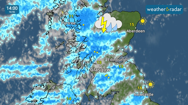
Weather radar at 14:00 on 13.10 showing widespread blue rain bands and lightning across western and central Scotland, with a thunderstorm symbol.
Heavy showers move through in the afternoon for Scotland bringing thunder too.

Tuesday brings heavy, thundery showers to parts of Ireland, Northern Ireland, and later on, Scotland.

Lightning strikes have already been seen in Co. Mayo, Ireland early in the morning where the heavy rain starts the day. This gradually move north-east through Northern Ireland towards Scotland in the afternoon.

While the rain will be heavy at times, the showers shouldn't persist for too long. Accumulations of up to 20 mm are expected north of Glasgow. There are no flood warnings active.

While the thundery showers are mostly in these areas, heavy showers do descend into northern England as far south as the Yorkshire Dales. Elsewhere it's a relatively bright, albeit gusty Tuesday.

Keep track of the showers and lightningWeatherRadar
Ryan Hathaway
More on the topic
Autumn weather starting to appear. Your weather - Your shots. . . Sunday 11 October 2026
Split image showing golden sun rays shining through a tree in a misty field and a circular fallstreak hole in a blue sky with textured clouds.
Sunday 11 October 2026

Your weather - Your shots

Autumn weather starting to appear
Heavy rain builds through the day. Irish warnings issued. . . Thursday 8 October 2026
Weather map showing widespread heavy rain across western and central Ireland, with blue precipitation bands and a red triangular rain warning symbol.
Thursday 8 October 2026

Irish warnings issued

Heavy rain builds through the day
Windswept Friday as gusts spread wide. Across the UK and Ireland. . . Thursday 8 October 2026
Wind map showing gusts of 40 mph near Dublin, Liverpool and Cardiff, 35 mph near Glasgow and London, and a strong wind warning symbol.
Thursday 8 October 2026

Across the UK and Ireland

Windswept Friday as gusts spread wide
All weather news
This might also interest you
New records for England and Wales. Broken again tomorrow?. . . Thursday 25 June 2026
Temperature map of southwest Britain on 25.06 showing extreme heat across southern Wales and southwest England, with Bute Park in Cardiff highlighted at 34.2°C and Yeovilton at 36.4°C amid widespread deep red heat zones.
Thursday 25 June 2026

Broken again tomorrow?

New records for England and Wales
Storm Chandra makes impact. Severe gales & heavy rain. . . Tuesday 27 January 2026
Split image showing strong winds over the UK on a forecast map and widespread rain and snow on a weather radar map.
Tuesday 27 January 2026

Severe gales & heavy rain

Storm Chandra makes impact
A stormy week in the skies above. Your weather - Your shots. . . Sunday 30 August 2026
Split image showing lightning branching beneath dark storm clouds above rooftops on the left and an orange-pink sunset over a calm sea on the right.
Sunday 30 August 2026

Your weather - Your shots

A stormy week in the skies above
All articles
Weather & Radar

Weather & Radar is also available on

Google Play StoreApp Store

Company

Contact us Privacy Policy Legal info Accessibility statement

Services

Uploader

Socials

facebooktwitteryouTubelinkList