Home
Weather Dublin
WeatherRadar
RainfallRadar
TemperatureRadar
WindRadar
LightningRadar
Weather News
Editor's Pick
Discover the app
Weather widget
Contact us
Apps
    Home / Editor's Pick /

    When will snow return? Why snow forecasts can be unreliable

08:00
17 November 2026

When will snow return?
Why forecasting snow is so tricky

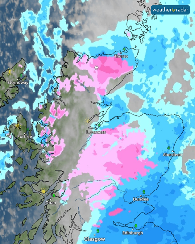
Weather radar showing widespread pink snow bands across northern and central Scotland, with blue rain areas near Aberdeen and Edinburgh and temperatures of 3–6°C.
Pinks on the WeatherRadar show snow!

Snow and sleet showers fell across the Highlands this weekend, but forecasting snow is more difficult than you might think. Predictions beyond three days are particularly unreliable, as snow depends on several factors, including temperature, altitude and location.

Snow becomes more likely when temperatures fall below 2°C, with sub-zero conditions often producing drier, powdery snow. However, whether snow reaches the ground depends on the temperature and humidity of the air it falls through.

Most precipitation begins as snow high in the atmosphere. If it passes through warmer air, it can melt into rain or sleet, even when temperatures at ground level are low enough for snow.

Altitude also plays a role, with temperatures generally decreasing as elevation increases. This explains why hills and mountains often experience more snowfall than lower-lying areas. Cities and coastal locations also tend to be warmer, meaning conditions can vary significantly over short distances.

Wind direction can quickly change the likelihood of snowfall too. Easterly winds often bring colder, drier air during winter, increasing the chance of snow in eastern areas. Changes in wind direction also shift the freezing level, while heavy precipitation can sometimes lower it enough to turn rain into snow.

Finally, the path of a weather system can determine where snow falls. Low-pressure systems often carry milder air, so even a slight shift in their track can make the difference between rain, sleet and snow. The best way to keep track is to watch the WeatherRadar this winter and look for the tell-tale signs of pink!

Ryan Hathaway

More on the topic

Severe weather on the Adriatic coast. Rain, storms and snow. . . Thursday 12 November 2026
The weather warning map shows heavy rain from Thursday to Friday, stretching from northern Italy through Slovenia and Croatia to Montenegro. Particularly heavy rainfall is expected along the northern Adriatic coast.
Thursday 12 November 2026

Rain, storms and snow

Severe weather on the Adriatic coast
Summer heat in the middle of November. Unusual temperatures. . . Tuesday 10 November 2026
The weather map shows the temperatures in south-eastern Europe and the Mediterranean region. It is particularly warm in the Balkans: temperatures in Belgrade are reaching 25 degrees. A red arrow indicates that warm air is flowing from the central Mediterranean towards Serbia. In Italy, Greece and Romania, too, temperatures are above 20 degrees in many places. By contrast, it is significantly cooler in the Alps and in parts of Central Europe.
Tuesday 10 November 2026

Unusual temperatures

Summer heat in the middle of November
Brazil: A spring full of storms. Rain and flooding. . . Friday 13 November 2026
Split. On the left, a weather map of Brazil showing clouds, rain and lightning. On the right, a thundercloud
Friday 13 November 2026

Rain and flooding

Brazil: A spring full of storms
All weather news

This might also interest you

A stormy week in the skies above. Your weather - Your shots. . . Sunday 30 August 2026
Split image showing lightning branching beneath dark storm clouds above rooftops on the left and an orange-pink sunset over a calm sea on the right.
Sunday 30 August 2026

Your weather - Your shots

A stormy week in the skies above
New records for England and Wales. Broken again tomorrow?. . . Thursday 25 June 2026
Temperature map of southwest Britain on 25.06 showing extreme heat across southern Wales and southwest England, with Bute Park in Cardiff highlighted at 34.2°C and Yeovilton at 36.4°C amid widespread deep red heat zones.
Thursday 25 June 2026

Broken again tomorrow?

New records for England and Wales
Storm Chandra makes impact. Severe gales & heavy rain. . . Tuesday 27 January 2026
Split image showing strong winds over the UK on a forecast map and widespread rain and snow on a weather radar map.
Tuesday 27 January 2026

Severe gales & heavy rain

Storm Chandra makes impact
All articles
Weather & Radar

Weather & Radar is also available on

Google Play StoreApp Store

Company

Contact us Privacy Policy Legal info Accessibility statement

Services

Uploader

Socials

facebooktwitteryouTubelinkList