Home
Weather Dublin
WeatherRadar
RainfallRadar
TemperatureRadar
WindRadar
LightningRadar
Weather News
Editor's Pick
Discover the app
Weather widget
Contact us
Apps
    Home / Editor's Pick /

    Storms and heavy rain – a massive low-pressure system off Iceland

11:55
16 September 2026

Impacting the UK & Ireland
Huge low-pressure system off Iceland

A powerful low-pressure system with a weather front stretching over 4,000 kilometres has developed over the Atlantic. Its centre is currently situated south-west of Iceland.

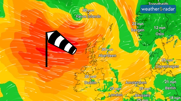
WindRadar showing strong winds over the North Atlantic, the UK, and Ireland.
The WindRadar forecast for Thursday shows stormy weather across the British Isles.

By Thursday, the system will move towards the UK and Ireland, bringing unsettled weather. There is a risk of storms and heavy rain. In Scotland in particular, winds will reach speeds up to 40 mph. In the Highlands, gusts of up to 55 mph are also possible.

As the weather system progresses, the low-pressure system will reach southern Norway. By the weekend, some areas along the west coast will see more than 100 mm of rain.

Track the system on the WeatherRadar
Weather & Radar editorial team
More on the topic
More rain needed to ease drought. Reservoirs still falling. . . Tuesday 8 September 2026
Aerial view of a depleted reservoir with exposed banks and a narrow winding stream through the dry basin, surrounded by green hills and roads.
Tuesday 8 September 2026

Reservoirs still falling

More rain needed to ease drought
A snowy winter in the Andes. Avalanches and storms. . . Tuesday 15 September 2026
Tuesday 15 September 2026

Avalanches and storms

A snowy winter in the Andes
Autumn colours light the skies. Your weather - Your shots. . . Sunday 13 September 2026
Split image showing a fiery red-orange sunset over a rural road and fields beside a golden sea sunset with a silhouetted seabird in flight.
Sunday 13 September 2026

Your weather - Your shots

Autumn colours light the skies
All weather news
This might also interest you
New records for England and Wales. Broken again tomorrow?. . . Thursday 25 June 2026
Temperature map of southwest Britain on 25.06 showing extreme heat across southern Wales and southwest England, with Bute Park in Cardiff highlighted at 34.2°C and Yeovilton at 36.4°C amid widespread deep red heat zones.
Thursday 25 June 2026

Broken again tomorrow?

New records for England and Wales
Storm Chandra makes impact. Severe gales & heavy rain. . . Tuesday 27 January 2026
Split image showing strong winds over the UK on a forecast map and widespread rain and snow on a weather radar map.
Tuesday 27 January 2026

Severe gales & heavy rain

Storm Chandra makes impact
Bright and warm conditions take hold. Spring-like outlook. . . Thursday 23 April 2026
Split UK map showing warm temperatures up to 21 degrees in orange on the left and clear sunny conditions with temperatures from 12 to 18 degrees on the right, with sun icons across the country.
Thursday 23 April 2026

Spring-like outlook

Bright and warm conditions take hold
All articles
Weather & Radar

Weather & Radar is also available on

Google Play StoreApp Store

Company

Contact us Privacy Policy Legal info Accessibility statement

Services

Uploader

Socials

facebooktwitteryouTubelinkList