Home / Editor's Pick /

Over the coming days - Jet stream brings unsettled weather to western and central Europe

15:34
11 September 2025

Over the coming days
Jet stream brings unsettled weather

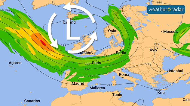
Weather map showing low pressure over Iceland and jet stream over Europe.The jet stream is located directly above Western and Central Europe.

The changeable weather will continue across large parts of western and Central Europe due to the jet stream.

The band of strong winds at an altitude of 10 kilometres acts as a highway for low-pressure systems, sending one low-pressure system after another across the continent.

Changeable showery weather will therefore prevail over the weekend from the UK and Ireland, to France, onwards to Germany and Scandinavia. In addition, there will often be brisk to strong winds. With temperatures frequently below 20 degrees, there will be no sign of summer weather to start autumn.

Dennis Oswald
Ryan Hathaway
More on the topic
Red moon during a total lunar eclipse in the night sky.
Friday 5 September 2025

Lunar eclipse on Sunday

Red moon in the Earth's shadow
Split weather map image. On the left, a rainfall and temperature map of the UK shows bands of rain (in blue) stretching across much of Britain and Ireland, with temperatures ranging from 14°C in Glasgow to 18°C in London. On the right, a pressure map of Europe highlights a deep low-pressure system to the west of Ireland and the UK, marked by tightly packed blue isobars and a swirl symbol.
Monday 8 September 2025

Storm Amy

Potential for named storm this week
Split weather map comparing two wind conditions over the Atlantic. The left side shows a powerful cyclone near the US East Coast, with a distinct eye surrounded by intense purple and red bands of strong winds. The right side shows calmer conditions, mostly green shading with lighter winds illustrated by white streamlines and small yellow patches. An arrow in the centre indicates the transition from storm to calmer weather.
Wednesday 10 September 2025

Since Erin

Hurricane season exceptionally calm
All weather news
This might also interest you
Sunday 24 August 2025

Your weather - Your shots

Mammatus clouds widely spotted
Monday 25 August 2025

Bank holiday outlook

Warm day turning gusty in places
Weather map of the UK and Ireland showing scattered showers with cloudy patches across much of the region, especially around western and northern areas. Sunshine symbols appear over London, Cardiff, and parts of southern England, while temperatures range from 17°C to 18°C in most places. Areas of heavier rain are visible over the Atlantic to the west.
Friday 29 August 2025

Breakfast brief

Unsettled conditions into the weekend
All articles
Weather & Radar

www.weatherandradar.ie

facebooktwitteryouTubeContact uslinkList
Privacy Policy | Legal info | Accessibility statement