Home
Weather Dublin
WeatherRadar
RainfallRadar
TemperatureRadar
WindRadar
LightningRadar
Weather News
Editor's Pick
Discover the app
Weather widget
Contact us
Apps
    Home / Editor's Pick /

    Severe thunderstorms - The monsoon has India firmly in its grip

12:00
9 July 2026

Severe thunderstorms
The monsoon has India firmly in its grip

The monsoon is in full swing over India, bringing around 80% of the country's annual rainfall within a few months, this is a vital time for the country.

Thunderstorms can be seen daily on the WeatherRadar, these also trigger floods and landslides.

Did you know?

The word ‘monsoon’ comes from Arabic and translates as 'season’. 

The monsoon follows the same pattern every year. In early June, it first starts to rain in Kerala, the southernmost state. The rain then spreads north-westwards. In early July, it reaches the north-westernmost states – as it has done this year.

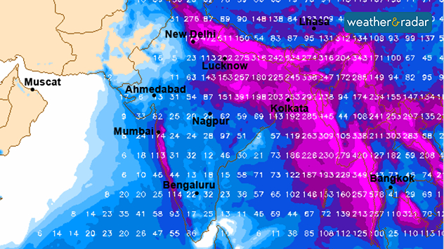
The forecast rainfall in India up to the end of next week

This year, the monsoon began a few days later than usual, following a very dry and hot June in India. The rain is therefore urgently needed. By the end of next week, rainfall is expected to exceed 300 mm in some areas.

Monsoon – The cause behind it all

The monsoon occurs because the land and sea heat up to different degrees depending on the season. This, in particular, causes the wind direction to change.

In summer, the wind in India shifts to the south-west, carrying moist air from the sea, bringing heavy rainfall far inland.

In winter, it is exactly the opposite: the wind blows mainly from the north to north-east, from the dry mainland, so there is hardly any rain.

Weather & Radar editorial team
More on the topic
Yet another typhoon in the Pacific. Gusts of over 185 mph. . . Friday 3 July 2026
Wind forecast map of the western Pacific showing a powerful typhoon east of Guam with a well-defined eye, strong wind circulation, and a windsock warning icon.
Friday 3 July 2026

Gusts of over 185 mph

Yet another typhoon in the Pacific
Forest fires rage in southern Europe. Drought and wind. . . Monday 6 July 2026
Split screen. On the left, a weather map of France and Spain showing the plumes of smoke from the forest fires. On the right, a fire-fighting aircraft in action.
Monday 6 July 2026

Drought and wind

Forest fires rage in southern Europe
Heat-health alerts ahead of heatwave. Across England. . . Tuesday 7 July 2026
Temperature map of the UK and western Europe showing hot conditions across Britain, with temperatures reaching 33°C near London, 29°C around Cardiff, 24°C near Liverpool, and a large heat warning symbol highlighting elevated heat risk.
Tuesday 7 July 2026

Across England

Heat-health alerts ahead of heatwave
All weather news
This might also interest you
Flooding, gales, and heavy snow. Storm Chandra. . . Tuesday 27 January 2026
Split image showing aerial flooding in a town with muddy water covering roads on the left, and a rural road on the right blocked by heavy snowfall with vans stopped and a person walking in snow.
Tuesday 27 January 2026

Storm Chandra

Flooding, gales, and heavy snow
A frozen start to the weekend. Icy conditions. . . Friday 13 February 2026
UK temperature map dated 14.02 showing widespread subzero values in blue shading, with readings such as −4 in Glasgow, −3 in Dublin, and −2 in London, alongside a blue thermometer icon.
Friday 13 February 2026

Icy conditions

A frozen start to the weekend
Long-term trends need a pinch of salt. 40 °C in July?. . . Tuesday 30 June 2026
Temperature radar of 2022 heatwave where the all-time temperature record in the UK was set. Warning symbol overlain.
Tuesday 30 June 2026

40 °C in July?

Long-term trends need a pinch of salt
All articles
Weather & Radar

Weather & Radar is also available on

Google Play StoreApp Store

Company

Contact us Privacy Policy Legal info Accessibility statement

Services

Uploader

Socials

facebooktwitteryouTubelinkList