Home
Weather Dublin
WeatherRadar
RainfallRadar
TemperatureRadar
WindRadar
LightningRadar
Weather News
Editor's Pick
Discover the app
Weather widget
Contact us
Apps
    Home / Editor's Pick /

    Eastern Pacific: Risk of a hurricane off the coast of Mexico

13:00
21 September 2026

Storm and rain
Hurricane threat off the coast of Mexico

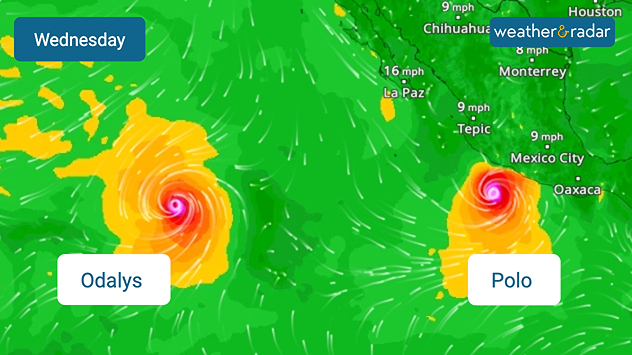
Tropical Storm Polo is rapidly gaining strength off the coast of Mexico. By the middle of the week, it could develop into a powerful hurricane and bring dangerous weather to the coast.

Tropical Storm Polo is currently moving southwards along the Mexican Pacific coast. It is set to encounter very favourable conditions over the coming days and is likely to intensify rapidly. A severe hurricane is expected by the middle of the week.

As things stand, the centre of the storm is likely to remain over the sea. Nevertheless, hurricane-force winds, a storm surge, and enormous amounts of rain are possible along the Mexican coast. By Thursday, around 300 mm of rain could fall in some areas.

Did you know?

Whilst the Atlantic hurricane season has been exceptionally quiet so far, the number of named storms in the Eastern Pacific is higher than usual for this time of year.

This significantly increases the risk of flooding and landslides, particularly in mountainous regions. And the hurricane season in the eastern Pacific remains very active: further west, the next tropical storm is already building up.

WindRadar: There are two hurricanes in the eastern Pacific.

Clemens Teutsch-Zumtobel
More on the topic
Autumn colours light the skies. Your weather - Your shots. . . Sunday 13 September 2026
Split image showing a fiery red-orange sunset over a rural road and fields beside a golden sea sunset with a silhouetted seabird in flight.
Sunday 13 September 2026

Your weather - Your shots

Autumn colours light the skies
Severe weather in the Mediterranean. Is a medicane on the way?. . . Monday 14 September 2026
A weather map shows a powerful low-pressure system over the Mediterranean, with warning symbols for storms and heavy rain.
Monday 14 September 2026

Is a medicane on the way?

Severe weather in the Mediterranean
Severe weather rolls on in Europe. Heavy rain and hail. . . Thursday 17 September 2026
Weather radar showing severe thunderstorms and frequent lightning over northern Italy.
Thursday 17 September 2026

Heavy rain and hail

Severe weather rolls on in Europe
All weather news
This might also interest you
Storm Chandra makes impact. Severe gales & heavy rain. . . Tuesday 27 January 2026
Split image showing strong winds over the UK on a forecast map and widespread rain and snow on a weather radar map.
Tuesday 27 January 2026

Severe gales & heavy rain

Storm Chandra makes impact
Historic Storm Éowyn arrives. On this day.... . . Saturday 24 January 2026
Split image showing a person in a yellow jacket struggling against strong winds and heavy rain on a street at night on the left, and an Irish wind forecast map on the right with red and purple shading, gusts up to 75 mph, and a wind warning icon, divided by a curved white line.
Saturday 24 January 2026

On this day...

Historic Storm Éowyn arrives
A frozen start to the weekend. Icy conditions. . . Friday 13 February 2026
UK temperature map dated 14.02 showing widespread subzero values in blue shading, with readings such as −4 in Glasgow, −3 in Dublin, and −2 in London, alongside a blue thermometer icon.
Friday 13 February 2026

Icy conditions

A frozen start to the weekend
All articles
Weather & Radar

Weather & Radar is also available on

Google Play StoreApp Store

Company

Contact us Privacy Policy Legal info Accessibility statement

Services

Uploader

Socials

facebooktwitteryouTubelinkList