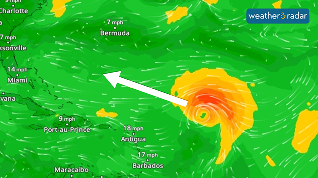
Home / Editor's Pick /

Atlantic: Tropical Storm Gabrielle on its way

10:00
18 September 2025

Quiet hurricane season
Atlantic: Tropical Storm Gabrielle on its way

You can follow tropical storm Gabrielle on our global WindRadar.

After a long wait, a tropical cyclone named Gabrielle has formed over the Atlantic Ocean. Over the next few days, the storm is expected to intensify into a hurricane and continue moving westward.

Did you know?

Gabrielle is the first Atlantic tropical storm since August 23rd. It is the longest break without a storm at this time of year in 65 years.

It will then head north towards the weekend and turn northeast. It may graze the Bermuda Islands in the process.

Will the hurricane season still pick up momentum?

At the end of the month, however, models indicate better conditions for tropical storm development. As water temperatures are very high, a late hurricane season is possible. Last year, several cyclones followed after a quiet period in September.

Even Central Europe could be indirectly affected in October as remnants of tropical systems influence weather on this side of the Atlantic.

Exceptionally calm hurricane seasonread more
Sebastian Keßler
Ryan Hathaway
More on the topic
Split weather map comparing two wind conditions over the Atlantic. The left side shows a powerful cyclone near the US East Coast, with a distinct eye surrounded by intense purple and red bands of strong winds. The right side shows calmer conditions, mostly green shading with lighter winds illustrated by white streamlines and small yellow patches. An arrow in the centre indicates the transition from storm to calmer weather.
Wednesday 10 September 2025

Since Erin

Hurricane season exceptionally calm
Split weather map of the UK and Ireland highlighting strong winds on Monday, 15 September. The left side shows gust speeds, with 55 mph around Dublin and Liverpool, and 45 mph near Cardiff and London, linked to a low-pressure system over the North Sea. The right side shows wind warning levels, with yellow (level 1) across much of England, Wales, and Northern Ireland, and orange (level 2) in western Ireland and parts of western Wales. A wind warning symbol is displayed in the centre.
Sunday 14 September 2025

Gales again

Continued warnings to start the week
Map showing the water temperature of the North Sea. A value of 15.7 degrees is displayed in the centre. The coastal regions of England, the Netherlands, Germany and Denmark are visible.
Thursday 11 September 2025

Lots of rain in sight

New heat record in the North Sea
All weather news
This might also interest you
Sunday 24 August 2025

Your weather - Your shots

Mammatus clouds widely spotted
Split weather map showing the UK and Ireland. The left side illustrates strong winds circulating around a low-pressure system, with gusts of 20–30 mph highlighted in orange and yellow. The right side shows radar imagery with widespread blue rain bands and patches of thunderstorms, especially over northern England and Scotland.
Thursday 28 August 2025

Breakfast brief

Remaining widely unsettled
Sunday 17 August 2025

Your weather - Your shots

Summer shots from a warm week
All articles
Weather & Radar

www.weatherandradar.ie

facebooktwitteryouTubeContact uslinkList
Privacy Policy | Legal info | Accessibility statement